 These arches are in a BLM Special Management Area so you
will need a permit to hike the Coyote Buttes to visit it. From
Rt. 89 in Utah, turn south on FR 1065 (the House Rock Valley
Road) and drive one mile south of the turnoff to the State Line
Campground (line between Arizona and Utah). Park on the west
side of the road in a large camp area. Hike east over a low ridge
on a cattle trail. Cross the sage brush flats, aiming for the south
side of a gulch in orange foothills. Look for the trail gash on the
side hill (do not take this trail). Find an old cattle trail on the south
side of the gulch, close to the mouth of the gulch, and below the
gulch previously mentioned. Be sure to find this trail, because
crossing the foothills will be rough otherwise. Go over the
foothills and when on the east side, trend south into the upper
regions of Sand Cove. Here is the “not recommended” part: hike
up-canyon to the checkerboard slope of sandstone and very
carefully wind up it to the Navajo Sandstone (white) layer. This
is a dangerous climb and is recommended neither by the
author nor by Rob Jones. Once on top of the Navajo sandstone,
hike north about a mile to the coordinates for the arches. The
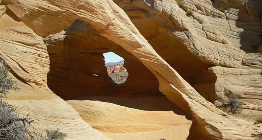
arches are difficult to see until you are in the depression with
them. Total hiking distance is about 4.5 miles one way, and
involves 2500 ft. of elevation change. UTM for the arches-
12S 410513E 4094317N , Elev. 4880 ft. For reference, the car
park is at about 12S 407994E 4093837N.
These arches are in a BLM Special Management Area so you
will need a permit to hike the Coyote Buttes to visit it. From
Rt. 89 in Utah, turn south on FR 1065 (the House Rock Valley
Road) and drive one mile south of the turnoff to the State Line
Campground (line between Arizona and Utah). Park on the west
side of the road in a large camp area. Hike east over a low ridge
on a cattle trail. Cross the sage brush flats, aiming for the south
side of a gulch in orange foothills. Look for the trail gash on the
side hill (do not take this trail). Find an old cattle trail on the south
side of the gulch, close to the mouth of the gulch, and below the
gulch previously mentioned. Be sure to find this trail, because
crossing the foothills will be rough otherwise. Go over the
foothills and when on the east side, trend south into the upper
regions of Sand Cove. Here is the “not recommended” part: hike
up-canyon to the checkerboard slope of sandstone and very
carefully wind up it to the Navajo Sandstone (white) layer. This
is a dangerous climb and is recommended neither by the
author nor by Rob Jones. Once on top of the Navajo sandstone,
hike north about a mile to the coordinates for the arches. The
arches are difficult to see until you are in the depression with
them. Total hiking distance is about 4.5 miles one way, and
involves 2500 ft. of elevation change. UTM for the arches-
12S 410513E 4094317N , Elev. 4880 ft. For reference, the car
park is at about 12S 407994E 4093837N.
|
| Photo and Directions by Rob Jones Trip Report |

|
Natural Arch and Bridge Society Home Page |
|
About Bob |
|
Return to Bob's Arches Home Page |
|
Return to Arizona Arches |