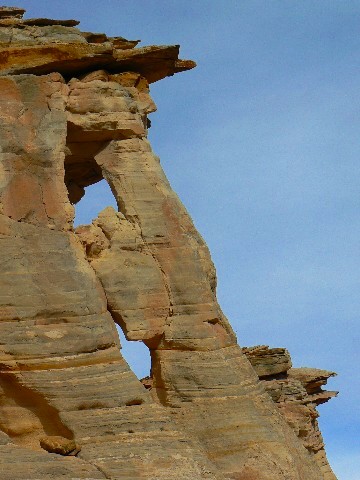
 It's 4.5 miles from the tarmac (Hwy 12) to the side road leading to the wash for the Jumbo Arch loop. Park on the East side (not too far from a corral on the West side) and walk down a brief track and across the main wash. Once you have fought your way through the tamarisk in the main wash, and are on the bench above the wash, walk down canyon and turn left (N) at the next wash coming in from the N. The distance from the car park at the main road and this turn is about 1/3 of a mile. Walk up the wash and note Chock Nut Arch (named for the chock rock in the center of the arch) on your left as you walk up canyon. In about two miles from the car park, you go into a walkable narrows which soon end at a dry falls. Retrace your steps a hundred yards or so from the falls and look up about 50' for the Vreeland Pillars. You can scamper out here, and, after admiring the VP, set a course cross country for Little Jumbo. You encounter a low plateau (which you can scramble over), and you may scramble down easily near Little Jumbo. See the map for general layout and GPS coordinates. Return the way you came, or set a course to the left of the nearby teepes, and you may meet an old horse trail that returns you to the main wash (Alvey Wash) and back to the mouth of the Chock Nut Arch wash.
Carpark approx. at: 12 S 457461E; 4170131 N; WGS84. (4.5 miles South of Hwy 12) Chock Nut Arch at: 12 S 458001E; 4170939N; WGS84. Directions and photo by Rob Jones Trip Report |
