 This is a difficult arch to find and get to. Even having been to it,
I couldn't find it the next time I tried. I suggest having the topo map and
even a GPS unit would help. Driving the Allvey Wash Rd. 4 miles from
Main St. in Escalante will get you to Coal Bed Canyon where parking
a 2wd car will be difficult. Hike or 4wd west in Coal Bed 1 mile to the
first canyon on the right- Mitchell Canyon. Hike Mitchell to the fourth
drainage on the right at 37deg.43'40" N 111deg.39'27"W on the Canaan
Creek,UT topo map. Hike 0.4 miles up the drainage to where it turns
right, but go straight ahead to the cliff there. Climb 200 ft. on the steep
side to the plateau on top and continue walking up 0.4 miles to the
arch at 6880 ft., 37deg.44'23" , 111deg.l39'46".
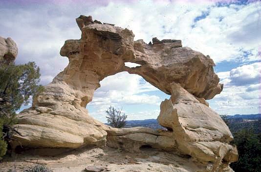
This is a difficult arch to find and get to. Even having been to it,
I couldn't find it the next time I tried. I suggest having the topo map and
even a GPS unit would help. Driving the Allvey Wash Rd. 4 miles from
Main St. in Escalante will get you to Coal Bed Canyon where parking
a 2wd car will be difficult. Hike or 4wd west in Coal Bed 1 mile to the
first canyon on the right- Mitchell Canyon. Hike Mitchell to the fourth
drainage on the right at 37deg.43'40" N 111deg.39'27"W on the Canaan
Creek,UT topo map. Hike 0.4 miles up the drainage to where it turns
right, but go straight ahead to the cliff there. Climb 200 ft. on the steep
side to the plateau on top and continue walking up 0.4 miles to the
arch at 6880 ft., 37deg.44'23" , 111deg.l39'46".UTM-12 441541E 4177175N (NAD83/WGS 82datum) (There is a similarly-named arch in the San Rafael Swell) Photo and Directions by Ted Dahlmann |
