 This window is about 19 road miles SW of Sedona. From the intersection of Highways 89A and 179 in Sedona (commonly called “the Y”), drive SW on 89A for 9.5 miles, then turn right onto dirt Forest Road (FR) 525. Stay on FR 525 for about 2.8 miles, then turn left onto FR 525C. Drive FR 525C for 6.6 miles, then turn right onto FR 9530. This intersection is at approx. UTM 12S 410645E 3864199N (WGS84). Park at this junction unless you have thick sidewall tires. When we hiked to the Roost, FR 9530 was not marked. You will know you have gone 0.2 miles too far if you have descended into a drainage, and encounter the Casner Mtn. trail sign at the drainage.
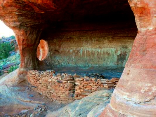
Start walking FR 9530 East toward the salmon-colored sandstone loaf (the Roost) about a mile away. Do not take FR 9530B, continue straight ahead. After about 1.1 miles from the junction of FR 525C and FR 9530, you are adjacent to the Roost. Look down into the drainage separating the road and the Roost for a trail (you will see a wilderness marker containing an announcement about leaving alone cultural areas). Head down this user-created trail and up the other side, where you begin contouring around the N side of the Roost. Start climbing toward the top of the Roost, breaking off to the left about a hundred feet below the summit. Contour across a slickrock slope and you will soon (200 feet) see the alcove containing the window and a refurbished ruin. This alcove is at approximately: UTM 12S 411642E 3865771N (WGS84), approx. 5100’ elevation.
This window is about 19 road miles SW of Sedona. From the intersection of Highways 89A and 179 in Sedona (commonly called “the Y”), drive SW on 89A for 9.5 miles, then turn right onto dirt Forest Road (FR) 525. Stay on FR 525 for about 2.8 miles, then turn left onto FR 525C. Drive FR 525C for 6.6 miles, then turn right onto FR 9530. This intersection is at approx. UTM 12S 410645E 3864199N (WGS84). Park at this junction unless you have thick sidewall tires. When we hiked to the Roost, FR 9530 was not marked. You will know you have gone 0.2 miles too far if you have descended into a drainage, and encounter the Casner Mtn. trail sign at the drainage.
Start walking FR 9530 East toward the salmon-colored sandstone loaf (the Roost) about a mile away. Do not take FR 9530B, continue straight ahead. After about 1.1 miles from the junction of FR 525C and FR 9530, you are adjacent to the Roost. Look down into the drainage separating the road and the Roost for a trail (you will see a wilderness marker containing an announcement about leaving alone cultural areas). Head down this user-created trail and up the other side, where you begin contouring around the N side of the Roost. Start climbing toward the top of the Roost, breaking off to the left about a hundred feet below the summit. Contour across a slickrock slope and you will soon (200 feet) see the alcove containing the window and a refurbished ruin. This alcove is at approximately: UTM 12S 411642E 3865771N (WGS84), approx. 5100’ elevation.
|

|
Natural Arch and Bridge Society Home Page |
|
About Bob |
|
Return to Bob's Arches Home Page |
|
Return to Arizona Arches |