|
|

|
|
Natural Arches of Ahaggar National Park |
Index Page 4 - Youf-Ehakit Area |
|
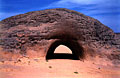
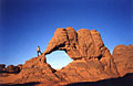
ALG-291, The Tunnel, Youf-Ehakit Area. 2.6 meter span, 5 meter
height, 10.5 meters deep (measured). GPS 32Q 275282 2448817. We left the Tahaggart site and
ALG-290 in the morning and drove along the big oued of Tin-Tarabine,
which flows from the Hoggar mountains. Near midday, we arrived at the site of Youf-Ehakit (which
means "better than tent" in the Tamahaq dialect). Matali, our driver-guide, took us on
a 45 minute side-trip to a seldom-seen natural arch called locally "Le Tunnel". It is
as perfectly shaped a tunnel as it would be if man-made. We used the tunnel to park the Toyota
in the shade and had lunch inside.
|
|
|
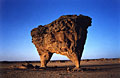
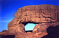
ALG-292, Bipod Arch, Youf-Ehakit Area. 5.6 meter span, 1.9 meter
height (measured). GPS 32Q 270429 2434359. On the way back from The Tunnel (ALG-291) to the
Youf-Ehakit main area we passed by this incredible "bipod" arch — a truly
amazing balanced rock with two legs, forming an arch. The thin leg is only 15 centimeters (6
inches) thick!
|
|
|
ALG-293, unnamed arch 15, Youf-Ehakit Area. 4.6 meter span, 3.2 meter height (measured). Close
to Bipod Arch (ALG-292) is this small but nice arch.
|
|
|
ALG-584, unnamed arch 16, Youf-Ehakit Area. 3.5 meter span (estimated). This small but
attractive arch is located 150 meters to the west of Bipod Arch (ALG-292).
|
|
|
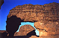
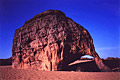
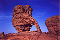
ALG-294, Elephant Rock, Youf-Ehakit Area. 7.6 meter span
(measured). GPS 32Q 267983 2436027. Five minutes from Bipod Arch (ALG-292), we stopped on the
top of a big sand dune overlooking the oued of Tin-Tarabine, here full of acacia trees. We
climbed down the dune with the Toyota and crossed the oued where the site of Youf-Ehakit is
signposted. Some distance from there another surprise awaited us! Two beautiful natural arches
side by side provided another bright cheer of the day. The main opening is in this nice
elephant-shaped rock. The second opening is ALG-295.
|
|
|
ALG-295, unnamed arch 17, Youf-Ehakit Area. 4.3 meter height (measured). This arch is adjacent
to Elephant Rock (ALG-294).
|
|
|
ALG-585, unnamed arch 18, Youf-Ehakit Area. 2 meter span (estimated). This arch is located on
the vicinity of Elephant Rock (ALG-294).
|
|
|
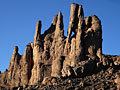
ALG-592, Needles Arch, Youf-Ehakit Area. 5 meter height
(estimated). From the Oued Tin-Tarabine and ALG-294 (Elephant Rock), drive north on the sandy
tracks (very sandy in some spots) for 15 minutes or much more (depending on the abilities of
your driver) to the foot of the rocky hill and the end of the tracks. From here, take the
cairned trail which climbs up in 45 minutes to the spectacular
Needles of Youf-Ehakit
(visible majestically from the Oued Tin-Tarabine). The arch is located in the first set of these
needles.
|
|
|
|
|
|
|
Index Page
|
|
Next Arch ALG-290
|
|