Classification and Origin of Aloba Arch
On the unusual origin of one of the world's most magnificent (and remote) natural arches
by Jay Wilbur
From SPAN April 2003
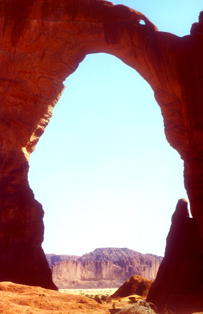
Aloba Arch from the WSW
Photo by Dr. Rolf Windheim - cover photo for SPAN, April 2003
INTRODUCTION
Aloba Arch, in addition to being an unusually large and magnificent arch, seems to have a very unusual origin as well. Aloba Arch is located in the remote Ennedi Range of the Sahara Desert in the country of Chad.
Attempting to classify a natural arch without actually examining it first hand in the field is fraught with risk. Photographs focus in on certain aspects of the arch and filter out others. Shapes and spatial relationships are distorted. Key attributes may be hidden from view. Some feature in the photo might appear to be one thing, but actually be something quite different. Distances and scale are easily misinterpreted.
Therefore, it is with considerable trepidation that I attempt to classify Aloba Arch here. I have never visited the arch and can only draw conclusions from the photographs and field data of others. Nevertheless, the set of still photos, videos, and other data that is available to me for interpretation paints a rather consistent picture. Therefore, I am sufficiently confident in what follows to risk the possibility of being proven wrong by a hoped for closer examination at some point in the future.
My classification of Aloba Arch uses the genetic taxonomy that was partially developed by the Standards and Definitions Working Group (SDWG) of the Natural Arch and Bridge Society (NABS) in the early 1990's, and is being gradually completed by me. I have documented this taxonomy on this website (Arch Info). This taxonomy is based extensively on the three references listed on this website.
Since I have chosen to use a genetic taxonomy, what follows is mostly a description of how the arch formed. It includes identification of the erosional processes that led to arch formation, the processes that governed subsequent development of the arch, and the sequence these processes followed. This scenario is, of course, hypothetical. It is of necessity sketchy and not very rigorous.
The field data on Aloba Arch that I examined are the still photos,
video, and maps provided to NABS by various members. In addition, I
consulted two technical papers on the general geology and climate history
of the Sahara. Although these provide some background information, they
may or may not apply specifically to the Ennedi region.
OBSERVATIONS
Any classification of a natural arch must be based on its observable attributes. The attributes that contribute most to a genetic classification are the contextual, morphologic, and geologic attributes described on the website given above. Using this framework, here are the relevant observations I extracted from the examined data.
Aloba Arch is located at the SE extremity of a sandstone outcrop. The sandstone that makes up this outcrop appears to be layered in two strata. The bottom layer appears to be more heavily cross-bedded than the top layer. The boundary between these two strata is at about the vertical mid-point of the arch. I do not know if these two strata are different formations, different members, or just different layers of the same member. However, nearby outcrops that consist only of the lower layer of sandstone appear to have eroded much more than this same layer in the outcrop capped by the upper layer. This suggests that the lower layer is softer than the upper layer.
The top layer of sandstone has been fractured into a dense field of parallel fins similar in appearance to the "Behind the Rocks" area southwest of Moab, Utah. The top of Aloba Arch, the lintel, is in one of these fins. If the joints that separate these fins extend down into the lower layer of sandstone, they have not widened in that layer as they have in the upper layer. In other words, the gaps between the fins only appear to extend down through the upper layer to the top of the lower layer. This suggests that the upper layer has been exposed to erosion for a much longer time than the lower layer, especially if the lower layer is indeed softer than the upper layer.
The fins all run in a NW to SE parallel direction. At its SE extreme, the field of fins narrows to a point. The fin that the arch is in is the SE-most fin in the field and has no flanking fins. This fin, including the SE abutment of the arch, projects into a bowed valley that has the appearance of an abandoned stream meander. Along the SW flank of the sandstone outcrop is an incised drainage valley.
The SW bank of this valley consists of heavily eroded outcrops of the lower layer sandstone intermingled with sand dunes. Of course the NE bank consists of the outcrop capped by fins. The fact that the upper layer is ubiquitous on one bank and absent on the other suggests that the drainage valley was incised into the lower layer only as it became exposed to erosion through uplift, and that this drainage did not exist during the time when only the upper layer was exposed, i.e., when the fins formed. The drainage now empties through the base of the arch into a sand flat.
The lintel of the arch is in the shape of a half catenary and is arched both on top and bottom. The sides of the lintel conform to the sides of the fin the arch is in. The opening of the arch is an upright, oval aperture with the long axis of the oval aligned with the vertical. The height of the opening, approximately 90 meters, is remarkable for more than its sheer magnitude. It is very uncommon for a large upright aperture to have a height twice its span. This alone suggests an unusual history for the arch.
Interestingly, if you divide the aperture in two along the short axis of the oval, i.e., horizontally by extending the boundary between the two sandstone layers, and consider these two halves of the opening separately, you are left with two large, but otherwise unremarkable openings. The top half of the opening is a half semicircular aperture, while the bottom half looks like a cross-section of the drainage valley. Viewed separately, either would have to be considered fairly common. But together as a single aperture, the opening is extremely unusual, perhaps unique.
All this data, taken together, is very suggestive of how Aloba Arch came into existence. It's unusual morphology is likely the result of a coincidence. This coincidence led to the sequential combination of two processes that normally do not appear together in the genesis of an individual natural arch.
GENESIS SCENARIO
Geologically, Aloba Arch is a very recent phenomenon. However, the sandstone it is in is very old. The scenario below attempts to explain the observed attributes of the arch, while remaining consistent with my sketchy understanding of the geologic and climatologic history of the Ennedi area.
Between 450 and 350 million years ago (mya), the two layers of sandstone were laid down in a continental shelf. This may have occurred during two separate depositional eras or during a single continuous one. Regardless, the result was a layer of harder sandstone over an older, softer layer of sandstone. In subsequent eras, these layers were buried beneath various younger strata.
Roughly 70 mya, volcanic doming occurred in this area. The flexing of these two layers, still buried under other strata, ranged from severe, over the central parts of the domes, to negligible, between the domes. In some places near the edges of these domes, mild flexing led to a series of long, parallel, evenly spaced, vertical joints in these sandstone layers. Where there was severe flexing, these layers became highly fractured.
About 6 mya, a period of general uplift and erosion began in this region that continues to today. About 30 thousand years ago (kya), erosion reached and exposed the upper layer of sandstone. This was during the last ice age. Glaciers covered much of Europe to the north. The climate of the Ennedi, although south of the ice pack, was cold and arid. Nevertheless, as uplift exposed more and more of this upper layer, three rates of erosion resulted. Where doming had caused it to be highly fractured, erosion was rapid and complete. In many places the layer disappeared altogether. Where doming had not occurred, the layer was very resistant to erosion and remains visible today. Where parallel vertical joints existed, water seepage, freeze expansion, and weathering widened these joints creating the field of sandstone fins that contains Aloba Arch.
About 15 kya, a buttress natural arch formed in the SE-most fin of this field. By the time it reached a mature stage, this buttress natural arch resembled modern day Corona Arch both in general appearance and size. Compression strengthening made its lintel very resistant to subsequent erosion. The top half of Aloba Arch had formed.
Uplift and erosion continued. About 10 kya, the coincidence occurred. Just as erosion began exposing the top of the lower layer of sandstone, the climate of the Ennedi changed dramatically. For the next four thousand or so years the Ennedi was warm and wet. Drainage channels became permanent streams. Where these flowed over the newly exposed softer layer of sandstone they incised into that rock as it was uplifted. One such stream formed along the SW flank of the outcrop of fins. As the stream cut downward into the softer layer, the harder layer above it stabilized and protected the NE bank of the stream. The opposite bank, lacking this protective cap, eroded faster.
For the first several of the 40 centuries that the wet climate lasted, this stream flowed around the fin that contained Aloba Arch. At some point, however, it found and widened a passage through the softer rock under the arch. Eventually, lateral stream piracy diverted the stream through the arch. Aloba Arch became a meander natural bridge!
Uplift and erosion continued. By about 6 kya, the climate of the Ennedi began transitioning to what it is today. At that time, the upper half of Aloba Arch looked pretty much like it does today. The lower half of the opening, however, looked quite different.
Between the time the stream diverted through the arch (approximately 8 kya) and the time the climate began to change to desert (6 kya), the volume of water carried by the stream was pretty heavy. The stream filled the base of the opening. But as the climate became more arid, the stream diminished. Erosion became more pronounced toward the center of the streambed. As uplift combined with stream erosion to lower the base of the natural arch, the abutments broadened back toward the center of the stream. There was less water flow, hence the channel narrowed.
By about 3 kya, desertification was complete. The climate was not much different from that of today. Still, there was enough occasional flow in the stream to keep lowering the base of the opening as uplift continued. During this last short period of a few thousand years, dunes crept into the area and weathering polished the sandstone more. Today, Aloba Arch is the result.
Does this scenario pass any reasonableness tests? For example, could uplift and stream erosion cut the lower half of the opening in the time that the scenario allots, about 8,000 years? Uplift rates for the Ennedi would have to be about 4 to 6 mm per year for this to have happened. The only information I have been able to find for the eastern Sahara ranges from 1 to 10 mm per year. Without specific data for the Ennedi, all I can claim is general consistency.
How likely is it that lateral stream piracy would re-channel the stream directly under an existing opening? Isn't this asking a lot of coincidence? The answer is that it wasn't just chance. The weight of the existing buttress arch would have preferentially compressed and strengthened the lower, softer sandstone layer that was directly under its abutments. The sandstone directly under the opening would not have been compressed and would therefore have been more likely to experience the seepage that eventually led to lateral stream piracy.
The scenario requires that the buttress arch formed about 15 kya, and that the lintel experienced little change over the past 10 thousand years while the lower half of the opening was cut. Is this reasonable? An age of 15 thousand years is consistent with age estimates made for the large sandstone arches of the Colorado Plateau. Without more detailed information about the specific sandstone formation/member involved, it is reasonable to assume that Ennedi arches last about as long. Further, the shape of the lintel is quite strong structurally and is the result of compression strengthening. Therefore, the lintel is much more resistant to erosion even than the fins in the same layer to the NW of the arch. Once a buttress natural arch has formed, the subsequent development of its lintel is much slower. Here again the scenario seems reasonable.
CLASSIFICATION
Even if the above scenario is essentially correct, does that necessarily imply that Aloba Arch should be classified as a meander natural bridge? Why not classify it as a buttress natural arch or as a hybrid of the two types? These questions are discussed next.
We start by pointing out that, regardless of the correctness of the genesis scenario, Aloba Arch must be classified as one of the following four possibilities:
- Buttress Natural Arch
- Meander Natural Bridge
- Hybrid of above two types
- Irregular Natural Arch
No other option makes any sense at all. Unfortunately, there are problems to varying degrees with these four choices as well.
If one does not accept the above genesis scenario, then Aloba Arch must be classified as an irregular natural arch. As discussed in the following paragraphs, its observed attributes are not fully consistent with either the buttress type by itself or the meander type by itself. One is left with having to speculate that some unique, complex, and undetermined set of erosional processes led to its formation. But if one does accept the genesis scenario, resorting to the irregular type in the taxonomy is unnecessary. Unless the scenario is shown to be fundamentally incorrect, classification based on the scenario is preferable to an alternative that amounts to giving up on trying to explain how the arch formed.
Classifying Aloba Arch as a buttress natural arch is problematic at best. Although the lintel is very consistent with this type, the lower halves of both abutments and the opening are not. Both abutments broaden outward significantly toward the base. The opening narrows toward the base and becomes much less aperture like. It is hard to believe that wall collapse, the key process of formation for a buttress natural arch, could account for this morphology. Wall collapse requires the wall to be uniformly thin. This is only true of the top half. Wall collapse usually acts to maintain a catenary or half-catenary shape. Again, this is only true of the top half.
Classifying Aloba Arch as a meander natural bridge also has at least one problem. Although there appears to be an abandoned meander and lateral stream piracy, it is also very obvious that the sandstone fin was not formed through this process. Rather, it is one member of a field of fins that formed in some global way, most likely the way described in the scenario. That there was a stream meander around the fin must be viewed as a coincidence, not as cause and effect.
At first, classifying Aloba Arch as a hybrid of a buttress natural arch and a meander natural bridge seems to have a great deal of appeal. But there is a significant problem with this approach as well. Although the genesis scenario strongly suggests a hybrid classification, the taxonomy does not allow this, and for good reason. Once hybrids are allowed in a genetic taxonomy its utility becomes virtually nil. Almost every natural arch will show some evidence for multiple genetic processes. Thus, most of them would wind up being classified as a hybrid of two, three, or more types. This would be confusing at best. It would certainly obviate the primary benefit of having a taxonomy in the first place. To avoid this, the taxonomy requires classification in accordance with the principle or primary process of formation. Hybrids are not allowed.
Of all the choices, classifying Aloba Arch as a meander natural bridge seems best. This choice has the fewest problems. Moreover, it best describes the current state of the arch, i.e., what lifecycle the arch is following now. Having been a buttress natural arch before it was a meander natural bridge makes Aloba Arch very unusual, perhaps unique, but does not really change it from being a meander natural bridge now.
CONCLUSION
Based on the whole set of data available to me, including geology data on the eastern Sahara and copies of photos, videos, and maps of the arch and its immediate surroundings, I have hypothesized a genesis scenario for Aloba Arch. In essence, this scenario claims that the arch began as a buttress natural arch, and remained that way for about the first half of its life. About 10 kya a coincidence resulted in the transformation of this arch into a meander natural bridge. These classification types are defined in the standard taxonomy referenced above.
If the scenario is correct, Aloba Arch is now best classified as a meander natural bridge. If the scenario is incorrect, Aloba Arch does not fit into the standard taxonomy other than as an irregular natural arch. Again, these conclusions must be qualified since they are not based on firsthand field observations. I would be happy to personally validate them should funding for such an expedition be found. I welcome all comments, questions, complaints, contrary opinions, and, of course, contributions.