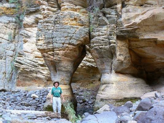
 Drive south from Flagstaff on I-17 to the Kelly Canyon exit
(Exit 331). Turn right (west) and drive FR 631 about a mile to
to a gravel pit. Stay to the left, above the pit and continue as far
as you feel safe following the rough farm road. Park and hike to
the end of the road which is about 3 miles from the freeway. Hike
into a dry, gnarly ravine which empties in 200 yards into
Pumphouse Wash . Turn left into Pumphouse Wash
(downstream), and hike the left shoreline (left going down
stream) for about a mile. Watch for the arch where the canyon
narrows just below a major side canyon (James Canyon) on your
left (NE). The arch is in the streambed and usually has water
surrounding it. The UTM coordinates for Pumphouse Wash Arch
are about 12S 434407E 3877877N; WGS84 at about 6000 ft.
elevation.
Drive south from Flagstaff on I-17 to the Kelly Canyon exit
(Exit 331). Turn right (west) and drive FR 631 about a mile to
to a gravel pit. Stay to the left, above the pit and continue as far
as you feel safe following the rough farm road. Park and hike to
the end of the road which is about 3 miles from the freeway. Hike
into a dry, gnarly ravine which empties in 200 yards into
Pumphouse Wash . Turn left into Pumphouse Wash
(downstream), and hike the left shoreline (left going down
stream) for about a mile. Watch for the arch where the canyon
narrows just below a major side canyon (James Canyon) on your
left (NE). The arch is in the streambed and usually has water
surrounding it. The UTM coordinates for Pumphouse Wash Arch
are about 12S 434407E 3877877N; WGS84 at about 6000 ft.
elevation.
|
| Photo and Directions by Rob Jones Trip Report |

|
Natural Arch and Bridge Society Home Page |
|
About Bob |
|
Return to Bob's Arches Home Page |
|
Return to Arizona Arches |