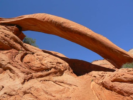
 This unique and delightful arch is near Buckskin Gulch, the longest slot canyon on the Colorado Plateau. The opening has a span of 35 feet. Turn south from Rt. 89 between Page, AZ and Kanab, UT near milepost 21 just east of the Paria Outpost) (and west of the BLM Paria contact station). Drive Rd. No. 750 as it climbs a knife-edge ridge above Long Canyon. Keep to the left, more traveled road, at all junctions. The road may have deep sand after about 5 miles. Upon crossing through a fence at about mile 8, park to the right under a juniper tree near the trail register for the Middle Route (sign says “Middle Route-hazardous route”). This is the trailhead for the Arch. From here, the hike is about 6 miles round trip. From the trail register, walk south along a fence line until you soon reach a cliff edge. Cross over the fence and find your way down the cliff to the slickrock at the base of the cliff. Turn east here and hike through the sand toward the next cliff protrusion about a mile away. If you were to continue on the marked route, you would be on the Middle Route to Buckskin Gulch. You may find an informal route through the sand, but in any event, continue to parallel Buckskin Gulch and the cliff band. The cliff band on your left will drop back into a drainage, then extend back out again. Where it extends out, you’ll see an upper cliff band and a lower one. Swing around the bottom of the lower set (stay in the sand and along the hoodoos). After the route begins to bend to the northeast, and you can see a large mounded plateau about a mile to the east, look for the Arch to the north among a group of red rocks, UTM 12S 418147E 4100188N(WGS94)
|

|
Natural Arch and Bridge Society Home Page |
|
About Bob |
|
Return to Bob's Arches Home Page |
|
Return to Elsewhere in Utah. |