 This arch NW of Sedona, AZ was visited on Sept. 18, 2006 by Rob and
Kathleen Jones. From “Y” (junction of highways 89A and 179) in
Sedona, drive 3.1 miles SW on 89A (toward the town of Cottonwood)
to Dry Creek Rd. Turn right onto Dry Creek Rd and drive 3 miles to
a “T” and a stop sign. Turn left onto FR 152C, signed for Boynton Pass.
Drive about 1.6 miles to another stop sign and turn left (this is still FR 152C)
and drive 0.5 miles to a posted trailhead on your right. At the time Rob
and Kathleen visited the area, construction work had started to pave this
section.
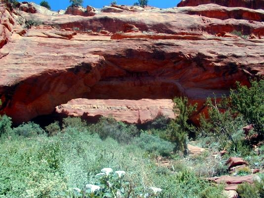
Hike up Fay Canyon on the marked trail. After hiking about 0.5 miles, an un-signed trail breaks off to the right, dips through the shallow drainage,
then scrambles up to the arch (about 200 ft. above and a quarter mile from
the drainage). The arch is visible from the main trail, but depending on the light, it looks more like an alcove than an arch. Reportedly, the arch has a span of 90 ft., a height of 15 ft, and a thickness of 25 ft. It is inside the border of the Red Rock-Sacred Mountain Wilderness. The UTM coordinates for the arch are approximately 12S 421316E 3863367N WGS84.
This arch NW of Sedona, AZ was visited on Sept. 18, 2006 by Rob and
Kathleen Jones. From “Y” (junction of highways 89A and 179) in
Sedona, drive 3.1 miles SW on 89A (toward the town of Cottonwood)
to Dry Creek Rd. Turn right onto Dry Creek Rd and drive 3 miles to
a “T” and a stop sign. Turn left onto FR 152C, signed for Boynton Pass.
Drive about 1.6 miles to another stop sign and turn left (this is still FR 152C)
and drive 0.5 miles to a posted trailhead on your right. At the time Rob
and Kathleen visited the area, construction work had started to pave this
section.
Hike up Fay Canyon on the marked trail. After hiking about 0.5 miles, an un-signed trail breaks off to the right, dips through the shallow drainage,
then scrambles up to the arch (about 200 ft. above and a quarter mile from
the drainage). The arch is visible from the main trail, but depending on the light, it looks more like an alcove than an arch. Reportedly, the arch has a span of 90 ft., a height of 15 ft, and a thickness of 25 ft. It is inside the border of the Red Rock-Sacred Mountain Wilderness. The UTM coordinates for the arch are approximately 12S 421316E 3863367N WGS84.
|
