|
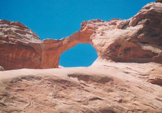
This arch is in southern Utah in the Navajo Nation. It is in the vicinity of Hawkeye Arch, qv and can be seen in the distance by a person standing on top of Hawkeye. It has an estimated span of 30 ft. Directions to the arch are as follows: At 0.0 mile, turn north onto Navajo Rt. 16 from AZ Rt. 98; at 13.6 miles, the pavement ends; at 32.3 miles fork right (left goes to the Rainbow Lodge ruins); at 37.7 miles, pass the turnoff (to left) to the Navajo Mountain School; at 41.3 miles go straight ahead at the Rainbow City junction; at 42.6 miles, stay left (right goes to Hawkeye Arch); at 43.2 miles, fork left; at 44.3 miles, fork right; at 46.1 miles, fork right; at 47.6 miles, fork left on faint 4wd track; at 47.7 miles, park; walk 1.5 miles north around NE-draining tributary of Desha Canyon, and then along east face of ridge to the arch. These directions are used by permission of Jay Wilbur who visited the arch in 1993. Ray Millar visited the arch in 2005 and took the photo. |
