 Powell Point is an easily recognizable feature from any of the
overlooks in Bryce Canyon. Its steep bluff marks the southern
end of the Table Cliffs Plateau (also the southern end of the
Escalante Mountains). Most of the trail to it is 2wd; but the trail
becomes 4wd closer to the Point. In approaching Bryce
Canyon on Utah Rt. 12, instead of turning south to Bryce Canyon,
turn north on Utah Rt. 22 going toward Widtsoe Junction. In
John's Valley, turn right onto Farm Rd. 132. After 11 miles, turn
right at the sign (very small and easy to miss) for Powell Point
(another trail comes in from the north here) The trail is very
narrow at this junction, but becomes somewhat wider. This trail
is pretty much for 4wd trail enthusiasts and is passable in good
weather. The trail ends at a turnabout where there is a marked
trailhead for PowellPoint. Start down the trail and at the first
switchback, continue straight off trail. There is no trail from this
point. Climb over and/or around fallen trees and ground cover
for appoximately 1500 ft. Where the trees end, you will be on
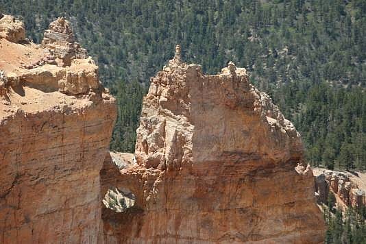
a point just west of Powell Point. Look to the east at Powell
Point. The Arch is at the bottom of the Point. You will have to
venture out onto loose caliche for a view of the Arch. Be very
carefull as it is a long way down. The location of the point from
which the Arch is visible is: 37deg.41.202'N 111deg.54.091'W
Powell Point is an easily recognizable feature from any of the
overlooks in Bryce Canyon. Its steep bluff marks the southern
end of the Table Cliffs Plateau (also the southern end of the
Escalante Mountains). Most of the trail to it is 2wd; but the trail
becomes 4wd closer to the Point. In approaching Bryce
Canyon on Utah Rt. 12, instead of turning south to Bryce Canyon,
turn north on Utah Rt. 22 going toward Widtsoe Junction. In
John's Valley, turn right onto Farm Rd. 132. After 11 miles, turn
right at the sign (very small and easy to miss) for Powell Point
(another trail comes in from the north here) The trail is very
narrow at this junction, but becomes somewhat wider. This trail
is pretty much for 4wd trail enthusiasts and is passable in good
weather. The trail ends at a turnabout where there is a marked
trailhead for PowellPoint. Start down the trail and at the first
switchback, continue straight off trail. There is no trail from this
point. Climb over and/or around fallen trees and ground cover
for appoximately 1500 ft. Where the trees end, you will be on
a point just west of Powell Point. Look to the east at Powell
Point. The Arch is at the bottom of the Point. You will have to
venture out onto loose caliche for a view of the Arch. Be very
carefull as it is a long way down. The location of the point from
which the Arch is visible is: 37deg.41.202'N 111deg.54.091'W
Photo by
|
