 See "Tantalus Flats Arch". Coming east from the Lower
Bowns Reservoir Rd. and before crossing Tantalus Creek,
park at the north end of the ridge in Tantalus Flats. Hike up
Maverick Draw along the west side of the ridge for about 2 miles.
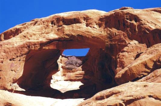
The Arches are shown on the Bear Canyon UT topo map. The
arches are visible, one above the other, from the base of the cliff.
For this view, you have to climb up the rocky cliff. From this
viewpoint, the shadow in the photo is the front arch, and sky
shows through the upper arch. The front arch has
a span of 65 ft. and the upper arch, 30 ft.
See "Tantalus Flats Arch". Coming east from the Lower
Bowns Reservoir Rd. and before crossing Tantalus Creek,
park at the north end of the ridge in Tantalus Flats. Hike up
Maverick Draw along the west side of the ridge for about 2 miles.
The Arches are shown on the Bear Canyon UT topo map. The
arches are visible, one above the other, from the base of the cliff.
For this view, you have to climb up the rocky cliff. From this
viewpoint, the shadow in the photo is the front arch, and sky
shows through the upper arch. The front arch has
a span of 65 ft. and the upper arch, 30 ft.
Photo and directions by
Ted Dahlmann
