|
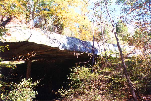
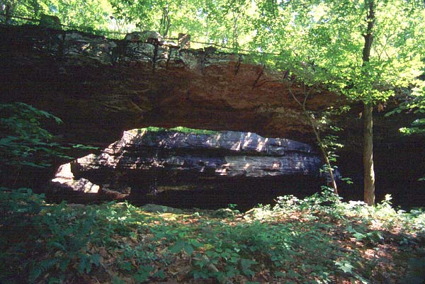
This photo by Ron Tagliapietra clearly shows how Mantle Rock, the longest span in the
Eastern U.S., gets its name.
|
LONGEST SPANS IN THE EASTERN U.S.
by Ron Tagliapietra (with David Brandt-Erichsen)
From SPAN January 2000 (with some updates)
Only seven spans east of the Mississippi are known to exceed 100 feet. Can you guess the four states involved? If you expand the list to those east of the Rockies, an additional one arch qualifies. Can you guess the additional state? This select group offers some good destinations for the next time you're "back east," but the rankings should be of interest even to those who never visit them. [This paragraph has been updated since original publication.]
1. Mantle Rock, Kentucky (KY-86)
154-foot span measured by Chris Moore
Livingston County near Joy
Photos: Cover photo (above) and Figure 1
The unrivaled longest span east of the Rockies is near the Ohio River across from Illinois. It was reported by Chris Moore in the Journal of Natural Arch Discoveries, who learned of it from a 1992 Kentucky Travel Guide. Information sheets are available from the Nature Conservancy, 642 W. Main St., Lexington, KY 40508. Take KY 133 west from Joy for 2 miles to a gravel road on the left beside a historical marker that says "Mantle Rock 0.5 mi." Park at a gate about 0.3 mi. down the gravel road, and then walk about 0.1 mi. to an information board at the entrance to the preserve. Continue the last 0.1 mile down the road until you see the arch on your right. With a tape measure, I obtained a measurement of 156 feet. This serves as an upper bound for the span and helps to validate Chris' measurement. The arch is historically significant, since it was used as a shelter by the Cherokee during the winter of 1838-39 on the Trail of Tears.
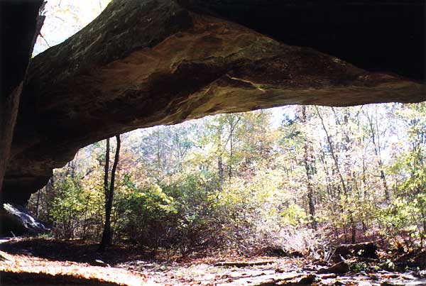
Figure 1: Mantle Rock. Photo by Ron Tagliapietra.
2. Unnamed Natural Arch, Alabama (24-9)
121-foot span measured by Ron Tagliapietra
Franklin County near Russellville
Photos: Figure 2; SPAN, January 1999, page 5
Take US 43 south from Russellville for 8.9 miles to AL 82. If you reach the better signed junction for AL 81, you went about a mile too far. Turn left (east) and go 0.3 mi. Just beyond the top of the first steep hill, turn right on a rutted track and proceed 50 yards to a turnaround. The track then turns into a trail and descends 100 yards to cross the arch. Having crossed the arch, descend through the split to stand below it. The property is apparently private but commonly visited. John Burns' earlier estimate of 130 feet drew attention to the arch, and my measurement of 121 feet establishes that the span deserves a place in this list. More precise measurements are needed to properly rank it in comparison to the next entry. I would also point out that although the bed was dry during my visit, there is a very obvious creek bed under the arch. Should it be considered the longest eastern natural bridge?
UPDATE: Jay Wilbur has measured this span at 122 feet.
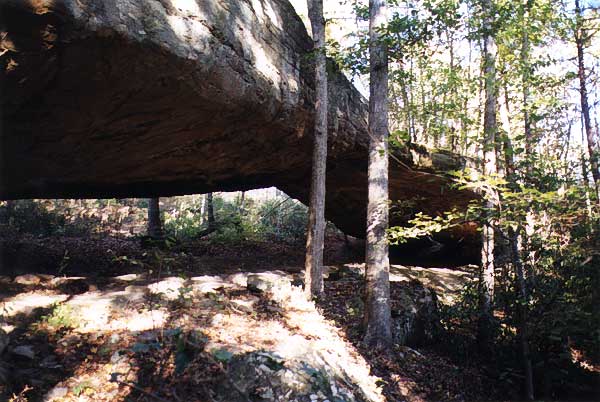
Figure 2: Arch 24-9 near Russellville, AL. Photo by Ron Tagliapietra.
3. Unnamed Arch, Illinois (14-9)
120-foot span paced off by Robert Vreeland
Pope County near Eddyville
Photo: Figure 3
This bridge is in Bell Smith Spring State Park and not too far from Mantle Rock if you use the free ferry boat ride over the Ohio River at Cave-in-Rock (a deep shelter cave with a skylight that makes it an arch of sorts). McPherson, in 50 Nature Walks in Southern Illinois (Vienna: Cache River Press, 1993), quotes a span of 125 feet and a height of 30 feet (with a photo on p. 86). Vreeland's number is within five feet, confirming this as the longest arch in the Midwest.
The network of trails confuses many, and some fail to realize that they have arrived even when walking across the arch. It is especially hard to view through, and requires descent from above using handholds. Nevertheless, those who persevere over gravel roads, routefinding, and scrambling will be well rewarded (bring your wide angle lens). To reach the bridge, exit I-24 at Vienna (Exit 16), and almost immediately turn east on IL 147. Drive 13 miles to Glendale, and turn left on IL 145. Drive six miles to Eddyville. From here the roads are gravel but passable and clearly marked to Bell Smith Springs. Follow the signs northwest 3.5 miles on FR 447 to FR 848. Turn left and go 1.5 miles to the dead end and parking area. The Natural Bridge Trail (yellow) makes a 1.5-mile loop and crosses the top of the bridge.
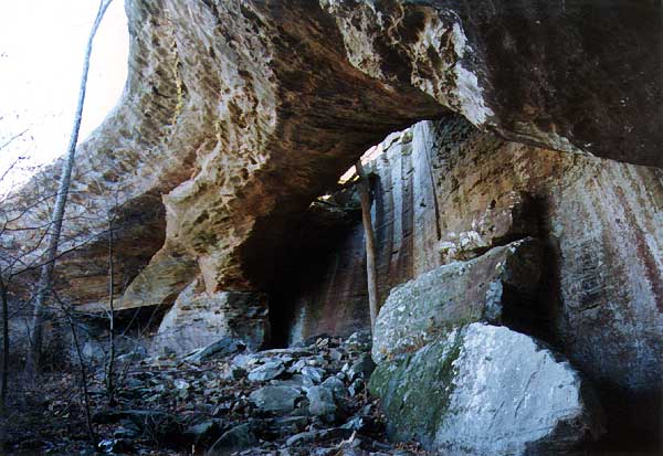
Figure 3: Arch 14-9 in Bell Smith Spring State Park, Illinois. Photo by Chris Moore.
4. Cracked Bluffs Arch, Tennessee
112-foot span measured by Ron Tagliapietra
Putnam County at the west end of Monterey
Photos: Figure 4; also Corgan and Parks, p. 56
This arch is on private property, north of a house just north of I-40. Although located only about 240 feet from an Interstate Highway, the arch gets little notice because it has only a 7-foot separation from the cliff behind. The span was reported at 110 feet by Corgan and Parks in Natural Bridges of Tennessee (arch #20), and also reported as 110 feet by Russ Manning in his Historic Cumberland Plateau (Univ. of Tenn., 1994). My own measurements with tape measure obtained 112 feet along the light opening separating the arch from the cliff wall behind. This is confirmatory of the previous reports, but it would be nice if a more expert NABS group took more precise measurements.
Manning also mentions an alternate name, Monterey Window. However, this is incorrect. The Window is actually a second arch on the other (south) side of the owners house. It's just beyond his property line on state property (and therefore can be visited). The Window is a pothole arch 58 inches wide and rappelers like to drop through this "skylight" into the shelter cave with a floor 60 feet below.
The owner of the main arch is Chris Callahan, who works at the NAPA auto parts store. Mr. Callahan is friendly and wanted to keep the arch open to visitors and even rappelers, but the insurance companies made this impossible. The dangerous cliffs have raised his rates to exorbitant levels and insurance that would protect him from visitors injured here would skyrocket the rates beyond belief. While he likes his scenic property, he said he thinks he would take a million dollars for it. Maybe we can start a lobby for the state to purchase his property and open another SNA (State Natural Area). It would have easy interstate access and the house could be used for a visitor center for both arches. Or maybe one of you would like to purchase it for a NABS branch office....
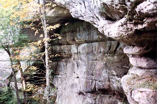
Figure 4: Cracked Bluffs Arch, Tennessee. Photo by Ron Tagliapietra.
5. Fern Bridge, Kentucky (KY-6)
110-foot span measured by Jay Wilbur
Carter County in Carter Caves State Park
Photo: Figure 5
To reach this arch, exit I-64 at exit 161 and follow signs five miles to Carter Caves State Park. Hike about a mile from the visitor center to the arch, or park at the end of the loop by the cabins and use the 0.1-mile connector trail to reach the steps that descend below the arch. The park boasts three other major arches as well (see SPAN, July 1995, page 10).
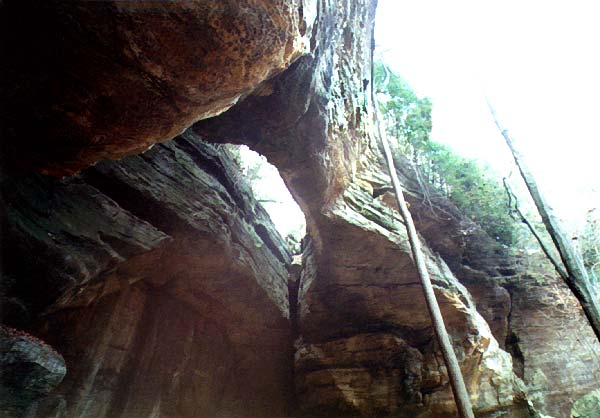
Figure 5: Fern Bridge (KY-6). Photo by Chris Moore.
6. Natural Bridge, Alabama (24-1)
105-foot span measured by Robert Vreeland
Winston County near the town of Natural Bridge
Photo: SPAN cover, January 1999; similar photo below
This tourist attraction charges a small admission fee to take the short level stroll to the arch. From the town of Natural Bridge, go west on US 278 to the park and gift shop. Note the smaller arch attached to it that creates a double. The park literature says the "bridge" is 148 feet long, 60 feet high, and 33 feet wide.
UPDATE: A new measurement by Jay Wilbur indicates that the longest span of this double arch is only 76 feet. Apparently Vreeland reported his measurement across both openings, rather than just the primary opening.
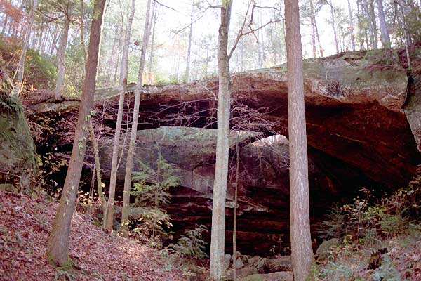
Natural Bridge of Alabama. Photo by Jay Wilbur.
7. Creelsboro Natural Bridge, Kentucky
104-foot span measured by Jay Wilbur
Russell County near Creelsboro
Photos: SPAN, August 1994, page 9; different photo below
The roads here can be confusing. I recommend going south from the Cumberland Parkway (Exits 49 or 62) to the junction of highways 55 and 379. From here follow KY 379 south for 9.5 miles to an unsigned gravel road on the left. (If you reach the sign announcing "end of state maintenance" you went too far. Also, 379 makes a sharp left in the small town of Creelsboro at mile 7.1. This is the last junction with KY 1078 and from here on you are on a road with no outlet.) Turn left on the gravel road and drive a tenth of a mile to a parking area by a monument to those who lobbied for preservation of the bridge. The bridge is left of the monument and down a stream gully. My rough measurement of 106 feet provides an upper bound and helps validate the Wilbur figure.
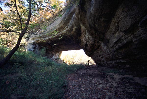
Creelsboro Natural Bridge, Kentucky. Photo by Jay Wilbur.
8. Alum Cove Natural Bridge, Arkansas
102-foot span measured by Robert Vreeland
Newton County near Jasper
Photos: SPAN, October 1997, p. 6; different photo below
This arch was reported to be "130 feet long" in a brochure on the "Alum Cove Geologic Area" from the Ozark-St. Francis National Forest. However, it was measured by Robert Vreeland at 102 feet (confirmed by Jay Wilbur, who got 101 feet). Drive south from Jasper on AR 7 for about 15 miles to AR 16. Turn right toward Deer, but proceed only a half mile and turn north on FR 1206, a good gravel road. Follow the signs 0.6 miles to the Alum Cove Geological Area. Hike down two sets of switchbacks to cross the top of the bridge at 0.2 mi. The short path just before the bridge descends to the base and also connects with a 0.7-mile loop trail that returns to the top of the bridge.
Alum Cove Natural Bridge, Arkansas. Photo by Jay Wilbur.
9. Natural Arch of Kentucky (KY-27)
100-foot span measured by Jay Wilbur
McCreary County near Parkers Lake
Photos: SPAN, July 1995 cover; October 1996, p. 7 (shown below)
About a mile south of Parkers Lake on US 27, turn west. Follow signs for a few miles on the paved roads to the parking area at the overlook with a nice view of the arch. A trail departs from the lot and passes under the arch in about a half mile. The arch is in the Daniel Boone National Forest.
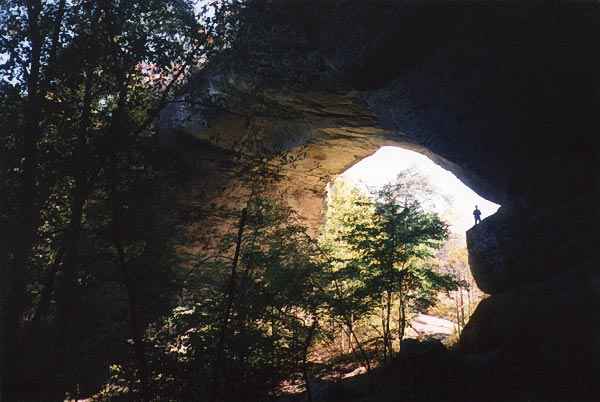
Stan Jones silhouetted at Natural Arch of Kentucky. Photo by David Brandt-Erichsen.
10. Arch Cave, Missouri
Reported 110-foot span unconfirmed
Miller County near St. Elizabeth
Arch Cave, also called Jurggenmeyer Natural Tunnel, was reported by Thomas Beveridge in Geologic Wonders and Curiosities of Missouri (p. 254) as being a natural tunnel 350 feet long, with a wider opening at one end of 150 feet tapering to a narrower opening at the other end of "about" 110 feet (making the span 110 feet unless there is a narrower place somewhere inside the tunnel). It would certainly be of interest to obtain a corroborating measurement of this feature.
[Update: A NABS group visited this feature on October 13, 2003. David Brandt-Erichsen measured the span at 60 feet (the interior was indeed narrower than either opening). Although it does not qualify as over 100 feet, the numbers belie the beauty and majesty of this feature.]
* * * * * * * * *
If the criterion is lowered to 90 feet, three more arches would make the list: 92-foot North Arch at Twin Arches in Tennessee's portion of the Big South Fork NRA; 90-foot Koger Arch nearby in McCreary County, Kentucky (both measured by Jay Wilbur); and 90-foot Natural Bridge of Virginia. The latter is reportedly America's most visited arch. The brochure that calls it the largest natural bridge and ranks it among the Seven Wonders of the World overstates the status of this otherwise fabulous arch, which doesn't even rank 10th place among Eastern spans.
Noticeably absent from the list are several lesser spans publicized as over 100 feet but when measured
turn out to be less. Rockbridge, Ohio (14-9), was reported at "about 100 feet long" in an
article "Ohio Natural Bridges" by Michael Hansen in Earth Science, Winter, 1988.
However, Vreeland reported the arch at only 79 feet. Whittleton Arch in Kentucky's Red River Gorge was
reported at "nearly 100 feet" in Russ Manning's Historic Cumberland Plateau. He
undoubtedly obtained this figure from the Forest Service, which usually reports the width of the entire
alcove rather than just the opening (see discussion in SPAN, July 1995, p.8). Chris Moore measured
Whittleton Arch at only 44 feet. Similarly, South Arch in the Big South Fork NRA in Tennessee was
reported at 135 feet but was measured by Jay Wilbur at 75 feet. Red Byrd Arch (KY-75) in the Red River
Gorge is reported by the Forest Service to be 110 feet. It is highly unlikely to be actually this large,
but so far nobody in NABS has measured the arch (any volunteers?).
[After this article was published, NABS member Rick Bolger measured the span of Red Byrd Arch at 56
feet.]
Finally, there is the Natural Stone Bridge in New York (13-4). One of the park brochures has a photo
which is captioned "View from romantic Meditation Isle of the massive 180' arch where a river
plunges beneath a solid rock mountain." If true, this would be by far the largest span in the East!
However, this is a long natural tunnel and to our knowledge the span has not been measured. The entrance
alcove may measure 180 feet, but judging from the exit opening the span is probably less than 20 feet.
|
Ron Tagliapietra has authored several books including
Great Adventurers of the 20th Century, The Seven Wonders of the World, and
Waterfalls of the States.
|