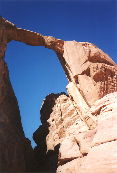
The vertiginous east side of the Rock Bridge of Burdah in the Wadi Rum.
ROCK BRIDGES OF THE WADI RUM DESERT
Story and photos by Guilain Debossens
From SPAN April 2000
The majestic landscape of the Wadi Rum Desert in south Jordan is well known around the world for its towering red sandstone walls and orange sand dunes leaning against them. This is an RSCN Reserve - a protected area of the Royal Society for Conservation of Nature. Most of the scenic mountains are 400 meters high containing deep fissures with sheer cliff headwalls caused by running water from the top. These canyons are called "siq" locally. The base of the mountains are granitic or purple sandstone formations and the summits are generally white sandstone shaped in domes or fins. This colorful desert offers continuously variable color shades with the course of the sun.
The Bedouin living there are very friendly and spending a night or bivouac in a Bedouin camp is an unforgettable experience. Bedouin people are also indispensable in guiding you to the natural arches.
In early March 2000 I spent 10 days looking for spans in this great country, under a full blue sky (except for one morning), and thoroughly enjoyed the whole experience. The desert country of the Wadi Rum is 290 kms south of the capitol city of Amman, or 40 kms north of Aqaba (Red Sea). Turn off from Desert Highway 15 at the sign for Rum and drive 16.8 kms to Desert Police Station. Proceed 11.6 km on road to Rum Village at the end of the pavement. The village here is poor with some light markets but an excellent rest house providing a fine restaurant and overnight stay in Bedouin tents.
Rum Village provides access to two wonderful arches (here called "Rock Bridges"), plus a smaller one. In the village you can take a "Bedouin Taxi" (Jeep tour) for a day-trip or simply a 1-hour excursion in the heat of the desert. The cost varies from 20 JD (Jordan Dinar), or about $30 US, to 45 JD for a full day.
My first outing experience was to go to the "Rock Bridge of Um Fruth." In the early morning I jumped into the back of an old Toyota 4WD with a Bedouin guide for a beautiful 12 km cross-country desert trip. On the way we passed by an unnamed rock bridge of about 4 meters span (Figure 1). The primary goal for the day can be seen in Figure 2. The Rock Bridge of Um Fruth is located at 29°28'06"N, 35°27'00"E and is an estimated 15 meters high. The top of this free-standing arch can be easily reached by slabs.
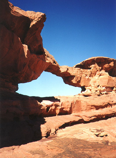
Figure 1: Unnamed 4-meter span (Jord-1).
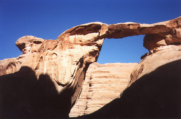
Figure 2: Rock Bridge of Um Fruth (Jord-2).
I arranged to have the Bedouin leave me here and I stayed most of the day around the arch. In late afternoon I started the long hike back, enjoying the great scenery of the desert sunset on my way, and arriving after dark, guided by the lights of the village in the distance.
The second day my objective was to visit the magnificent Rock Bridge of Burdah, the gem of the area. Starting at 7:30 am, a Bedouin guided me to the east across the remarkable valley of Khor El Ajram for a splendid 15 kms desert drive to Jebel Burdah (Burdah Mountain). The arch is visible from a sandy flat on top of the mountain. Getting up to the arch required one hour of strong effort, and I consider this arch as being of similar difficulty as Camelhead Arch in the San Rafael Swell. I recommend obtaining a Bedouin guide in Rum Village.
You arrive at Burdah on the west side. About 200 meters after the chute in the huge rock mass, there is a little cirque where all tracks converge. Here is the start of a very primitive path which ascends to the arch. The path is only marked with some light cairns and carved arrows. It is very often steep through slickrock and domes, and there are two exposed chimneys along the way for which a safety rope would be advised for inexperienced persons. The route is difficult to follow and requires skill at route finding. The view around the desert from the top is very grand, and you can walk across the archway without any difficulty - a most unique reward!
The spectacular arch (cover photo and Figure 3) is located at 29°28'24"N, 35°30'00"E and spans a deep gully. I have estimated this natural wonder at around 35 meters high, but it is situated as to make it very difficult or impossible to measure. In the late afternoon I descended to the desert floor, staying in my tent for the night at the bottom of a white sand dune (the second idyllic place for the day). The next day I backpacked out of the desert to Rum Village in nice 25 C weather (77 F).
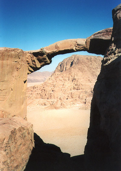
Fig. 3: The Rock Bridge of Burdah from the west side.
On the fourth day I planned to visit the famous "Rock Bridge of Kharaz" in the outskirts of the Rum. From Desert Highway 15 at the turnoff for Rum, drive north toward Amman for 3.5 kms and take the right exit toward Al-Quwayra. Drive 6.8 kms to the end of Al-Quwayra Village and turn on the right. Follow this paved road 3 kms to a dead end at the Garden in the Desert. From here, take a 4WD track northeast, following along a power line for approximately 6 kms. Then turn right (east) between two mountains into an obvious sandy valley. Drive east for 7 or 8 kms on the flat to Jebel Kharaz. The arch can be approached directly by jeep. More accurate distances cannot be provided due to the numerous parallel tracks and also because the odometers are usually out of order on old Bedouin vehicles. So a Bedouin guide is usually indispensable.
What I discovered there was quite amazing: There was not just one span but three exceptional arches very close to each other. The first one, called Rock Bridge of Kharaz (Figure 4) is about 34 meters in length, eroded in a thin fin of white sandstone. The top is easily accessible by climbing a small sand dune leaning against one side. The second arch (Figure 5), a large rock shelter of about 26 meters length, is only 200 meters from the first and is located at 29°48'31"N, 35°27'15"E. It is the first arch that is visible when you approach the area.
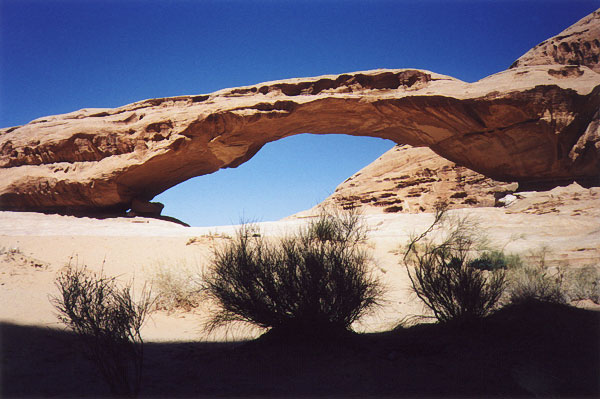
Figure 4: The 112-foot span of Rock Bridge of Kharaz (Jord-7).
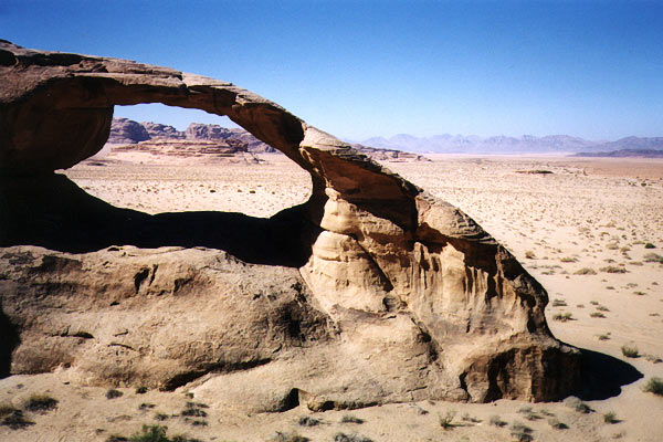
Figure 5: Jord-8 from the west side.
There is a Bedouin camp situated on the side of the main rock bridge. To reach the third arch, follow the faint tracks east from the Bedouin camp, going around a huge rock mass 500 meters to the arch (Figure 6). It is a cave type of 10 meters length, just on the right after bypassing a white fin of sandstone. There are also numerous Nabataen inscriptions and petroglyphs around the area. You should check with the Bedouins if you intend visiting this area.
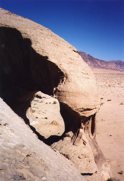
Figure 6: Unnamed arch Jord-9.
The arch data was obtained with tape measurement and the help of Bedouins. I decided to take the opportunity to camp under the Rock Bridge of Kharaz for the night, next to the Bedouin camp. A good choice! I enjoyed contemplating the arc of rock under the starry desert sky with Bedouins sitting around a camp fire, a glass of tea in my hand.
Next morning I awoke under overcast skies. Around 9 am, after the traditional "tea-time" in the Bedouin tent, I went back to Al-Quwayra Village to recover my rental car. I cut cross-country bearing north to diminish the distance of the walk and encountered an unexpected shower and low clouds and fog in the desert, where the altitude is about 1000 meters above sea level. This was sometimes a handicap in finding my starting point, but without trouble I arrived at midday to my car, enjoying the hot tea that a Bedouin woman gave me. In the afternoon a full sun returned.
I devoted the sixth day to find an arch called "Arch Tower" by European rock climbers, located in the vicinity of Siq-el-Barrah (Barrah Canyon), not so much a canyon but more of a narrow passage between two mountains. In the small oasis of Deiseh (Disi) I found an enthusiastic Bedouin who guided me in this area for only a few Dinar. He led me in the desert and fixed a rendezvous near 4 pm, and stayed during my exploration with his teapot and his "narghile." By chance I quickly found the arch, located at the east entrance of "Barrah Canyon" (at 29°34'29"N, 35°30' 12"E). It is a large buttress type estimated at 15 meters high. The photo in Figure 7 does not do justice to this beautiful arch.
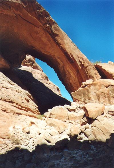
Figure 7: Arch Tower (Jord-5).
Directions to Arch Tower: From Rum Village drive north for 11.6 km to Desert Police Station. Turn right (east) and drive 7.8 km to Deiseh entrance, pass through the small village and then turn right off road on the mud flat. This flat is drivable for passenger car in dry periods. Cross south on the long tract of mud flat for 3 or 4 km and proceed into an obvious sandy valley south between two imposing mountains. The sandy valley absolutely requires a 4WD vehicle. Drive into the valley for 5 or 6 km, taking as landmark target the huge cubic rock with desert varnish visible in the distance, to the east entrance of Barrah Canyon. The arch is hidden behind this huge rock and is easily accessible by the talus slope in front of it.
The remaining days were devoted to other treks in the desert and I found three additional arches of good size (reported in the Journal). I then visited world-famous Petra, the marvelous carved city of the Nabataneans. I will never forget the beauty of the Wadi Rum Desert, the Bedouins' warm welcome, and of course the wonderful arches.
In the next few years I would like to go back again to the Sahara Desert country (Algeria, Niger, or Chad) and look for arches, provided however that the political situation there improves. Some adventurous NABS members may be interested. I have organized a half dozen trips in the past to each country (except for Chad) but alas this was before my interest in natural arches.
Return to SPAN article contents page