|
|

|
Natural Arches of Tassili National Park |
Index Page 2 - Tamrit Area - Map 2See Tamrit Panoramic Photo by Tom Budlong |
|
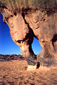
ALG-72, Tamrit Camp Arch, Tamrit Area. 1.75 meter span (estimated). From the small saddle (see
ALG-70), proceed on the trail east and then north across a gravel flat
about 5 km to the site of Tamrit (bivouac area). This arch is located on the side of some
ordered fins on the left of Sonatrach Camp (a petroleum company site with permanent
caretaker).
|
|
|
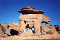
ALG-7, Dinosaur Arch, Tamrit Area. Largest opening, 0.9 meter span (estimated). GPS 32R 565794
2722535. From the hikers camp of Tamrit, cross south across a little flat about 150 meters to
the first outcropping of rock on the left of the trail. Find this arch among the rocks. A small
arch but very attractive.
|
|
|
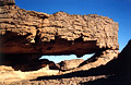
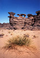
ALG-74, Outcropping Rock Arch, Tamrit Area. 9.0 meter span, 2.2 meter height (measured). GPS
32R 566128 2723305. From the huge cypress tree (near some shelters of stone) situated 300 meters
south of the Sonatrach Camp, walk SE for 400 meters toward a formation of outcropping rocks.
Find this arch among these rocks. If you don't have a GPS, ask the caretaker of Sonatrach Camp
for assistance.
|
|
|
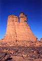
ALG-73, Window Tower, Tamrit Area. 2 meters high (estimated). From Tamrit Guelta (just behind
hikers camp), walk NE through the cypress valley along the oued (wash) for 500 meters and then
bear left (north) toward Tamrit Towers. Find this window up on one of these towers. There are a
lot of small arches in this area.
|
|
|
ALG-8, unnamed arch 1, Tamrit Area. 1.5 meter span (estimated). GPS 32R 565782 2725088. From
Tamrit hikers camp, walk NE through Sonatrach Camp and climb up behind it on slickrock about 700
meters to a flat area. This cairned route is difficult to follow so a guide is essential.
Proceed NE across a gravel flat toward Tan-Zoumaitek and the rock art site (Big Horn Fresco) for about 1.5 km. The arch is visible from the primitive trail on the right (east) at the
bottom of a corridor 200 meters ahead.
|
|
|
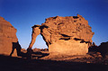
ALG-9, Elephant Rock, Tamrit Area. 1.6 meter span by 1.9 meter
height (measured). GPS 32R 565076 2725761. From ALG-8, retrace your steps to the primitive trail
and proceed NE on this trail for about 250 meters. The arch is visible from the trail on the
right (east) on an isolated rock.
|
|
|
|
|
|
Index Page
|
|
Next Arch ALG-10
|
|