|
|

|
Natural Arches of Tassili National Park |
Index Page 3 - Tin Itinen Area - Map 3 |
|
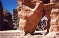
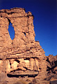
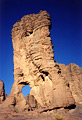
ALG-10, Shelter Arch, Tin Itinen Area. 2.5 meter span, 3.5 meter height (estimated). From Tamrit hikers bivouac area, take the same route as for ALG-8 to the flat area. Choice of trails can be very confusing in this gravel area so check with your guide. There are four different trails from there. One goes to Tan-Zoumaitek and the Big Horn Fresco rock art location via ALG-9 near the Great Canyon of Tamrit. Another trail goes to Tin-Aboteka via ALG-146 and ALG-147 (see Map 1). Two alternative trails go to the Tin-Itinen and Titeras-n-Elias areas. The shortest trail is used by hikers only. If you travel alone you take the donkey trail following the guide, the donkey driver, and the donkey caravan. Described here is the donkey trail to Tin Itinen: Once on the flat area bear east on the animal tracks along some isolated rock masses containing some light rock art. After about 3 km the trail enters a low canyon. Go through this canyon and after about 30 minutes the trail emerges into the fabulous rock spire forest of Tin-Itinen. Cross it following the primitive trail east and then NE until you reach a long corridor of rock. The arch is located on the side of the trail in the middle of this corridor. There is a similar arch behind this one. |
|
|
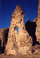
ALG-77, Allagh Arch, Tin Itinen Area. 7 meters high (estimated).
GPS 32R 567748 2725589. If you proceed straight ahead in the corridor from ALG-10 you will head
for ALG-11. To visit Allagh Arch instead, turn left from ALG-10 into an obvious corridor. Walk
through this corridor north for about 250 meters. ALG-77 is visible to the left in the tower.
From ALG-77 you can reach the area of ALG-75, 76, 78, 79, and 80 and the alternative trail to
Tamrit straight ahead, or you can retrace your steps to ALG-10. Allagh means spear in
Tamahaq.
|
|
|
ALG-11, Shadow Arch, Tin Itinen Area. 2 meter height (estimated). From ALG-10, proceed straight
ahead in the corridor for 100 meters to ALG-11.
|
|
|
ALG-12, Trailside Arch, Tin Itinen Area. 2 meter height (estimated). This arch is located a few
meters past ALG-11 at the corridor exit (left), on the side of the trail.
|
|
|
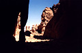
ALG-80, Figurine Arch, Tin Itinen Area. 2 meter span, lower (horizontal) opening (estimated).
From ALG-12 proceed on the trail NE for about 250 meters to an obvious flat bowl. Here is the
junction with the alternative trail from Tamrit and the forks for Sefar and Tin-Tazarift. The
area is very confusing, so be sure to check with your guide. From the bowl, take the alternative
trail toward Tamrit (west) for about 350 meters until you pass along side a natural arch with a
boulder inside the opening (this arch is not a major one and is not cataloged but is still a
useful landmark). ALG-80 is located just before this one near a thin rock (100 meters below two
sand dunes against the rocks). Note that in the photo it is a bit hard to spot the lower
(horizontal) opening because there is no sky through the opening.
|
|
|
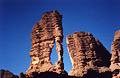
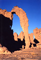
ALG-75, Takouba Arch, Tin Itinen Area. 10 meter span (measured) by
20 meter height (estimated). GPS 29R 567877 2728020. From the uncataloged arch with the boulder
in it (described with ALG-80), proceed on the trail toward Tamrit (west) for 200 meters and find
this arch off trail (north), 100 meters away. Takouba means sword in the Tamahaq dialect. Photo
taken at sunset.
|
|
|
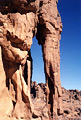
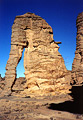
ALG-76, Irrekam Arch, Tin Itinen Area. 2 meter span by 8 meter
height (estimated). This arch is located 200 meters southeast of ALG-75. Irrekam is the Tuareg
name for these typical rock spire formations.
|
|
|
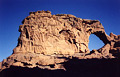
ALG-78, Esplanade Arch, Tin Itinen Area. 4.8 meter span by 3.2 meter height (measured). This
arch is located 200 meters south of ALG-76 in an esplanade of slickrock. Cross some outcropping
rock to get to it.
|
|
|
ALG-79, Tower Pillar Arch, Tin Itinen Area. 3.5 meters high (estimated). Find this arch 80
meters from ALG-78, at the base of a little spire. If you walk SE from this area through a large
corridor you return to ALG-10 and ALG-77.
|
|
|
ALG-81, Pendulum Arch, Tin Itinen Area. 2 meters high (estimated). At the bowl exit (see
ALG-80), take the trail NE to Tin Tazarift into a sandy valley for about 350 meters. The arch is
visible to the left (north) near some side "canyons".
|
|
|
|
|
|
Index Page
|
|
Next Arch ALG-13
|
|