|
|

|
Natural Arches of Tassili National Park |
Index Page 16 - Tin Kani Area - Map 7See satellite map of this area. |
|
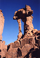
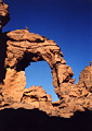
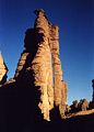
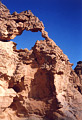
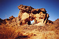
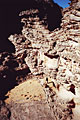
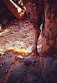
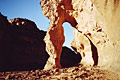
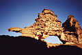
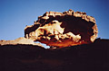
ALG-145, Curious Arch, Tan Zoumaitek Area. 3.3 meter height by 0.75 meter span (measured). GPS
32R 564642 2726033. From Elephant Rock (ALG-9), proceed northeast on
the trail to Tan-Zoumaitek site for a few meters and turn left (north). Follow the trail down
slickrock for 10 minutes to the great panel of rock art in
the shelter on the left. From there, Curious Arch is visible to the north with binoculars. Walk
about 400 meters down slick rock to the arch.
|
|
|
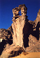
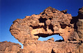
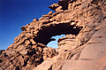
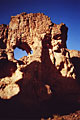
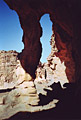
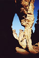
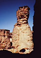
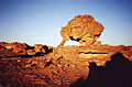
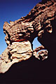
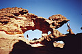
ALG-191, Trophy Arch, Tin Kani Area. 1.5 meter span (estimated). From
ALG-189 or from the Sefar bivouac area (see
ALG-57), leave the reefs and walk south across the plateau. Hike the
flat landscape on the trails (check with your guide) for about three hours to the reef of
Tin-Kani. When you approach the Tin-Kani site you have a great view from the top of a slickrock
slope (gully). From the top, climb down the sandy slope south and cross a little valley (wash).
On the other side, ascend the strenuous pass (cairned trail) to the flat bowl of Tissouar
(official campsite of Tin-Kani). From the campsite located at the bottom of the bowl, continue
on the trail (near an isolated spire) and climb up a rocky pass into a deep corridor marked with
cairns. At the exit of the pass, the trail passes a
beautiful balanced rock. From the balanced rock, continue on the trail and bypass the big enshrined sand dune 200
meters to the arch on the right side of the trail.
|
|
|
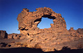
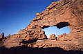
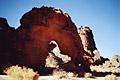
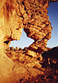
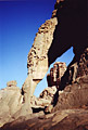
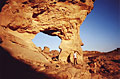
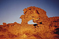
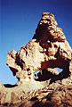
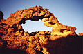
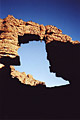
ALG-190, Tin-Kani Arch, Tin Kani Area. 25 meter height
(estimated). GPS 32R 571975 2718259. From Trophy Arch (ALG-191), proceed on the trail for about
150 meters to the third saddle that leads you out of the reef to the higher plateau. Once on the
flat continue on the trail southwest for about 300 meters and keep looking to the left (east).
The big arch is furtively visible 100 meters away. This is one of the largest arches found on
the Plateau top.
|
|
|
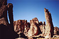
ALG-197, unnamed arch 34, Tin Kani Area. 2 meter span (estimated). From the view of Tin-Kani
Arch (ALG-190), leave the trail and cross the gravel flat for about 500 meters west to some rock
masses and this arch. The arch can be seen from the trail with binoculars.
|
|
|
ALG-198, unnamed arch 35, Tin Kani Area. 1.5 meter height (estimated). Find this arch behind
ALG-197.
|
|
|
ALG-199, unnamed arch 36, Tin Kani Area. 1.5 meter span (estimated). Find this arch beyond
ALG-197 on the low rock masses.
|
|
|
ALG-200, unnamed arch 37, Tin Kani Area. 1.5 meter span (estimated). Find this arch beyond
ALG-197 on the low rock masses.
|
|
|
ALG-201, unnamed arch 38, Tin Kani Area. 5.2 meter span (measured). Find this arch beyond
ALG-197 on the low rock masses. This arch is the more attractive of the set.
|
|
|
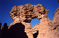
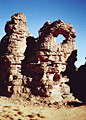
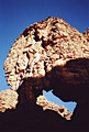
ALG-196, Colonnade Arch, Tin Kani Area. 3.5 meter height (estimated). From the view of Tin-Kani
Arch (ALG-190), proceed on the trail south for about 200 meters. The arch is visible from the
trail to the east. Leave the trail and walk 200 meters to the arch. The main trail you leave
there goes to Tin-Essou and Jabarren sites and Aroum Pass. Jabbaren site is reached from there
with about 6 hours hiking.
|
|
|
ALG-195, unnamed arch 39, Tin Kani Area. 3.7 meter span (measured). From Colonnade Arch
(ALG-196), continue a short way (following donkey prints in the sand if still visible) and turn
left. Follow the small drainage some distance to the entrance of a joint crack canyon. If dry
enough, go through this beautiful slot canyon with laurel and furze (a water plant) for about
200 meters to the exit. Then continue down corridor maybe another 200 meters or so to the arch
up on the right (see Map 7 ).
|
|
|
ALG-193, unnamed arch 40, Tin Kani Area. 3.6 meter height (measured). Farther down the corridor
from ALG-195, up on the rick to the right.
|
|
|
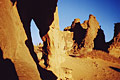
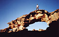
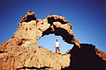
ALG-194, Surprise Arch, Tin Kani Area. 7.3 meter span (measured). GPS 32R 567524 2720805. This arch is
located farther down the corridor from ALG-193, hidden up on the rock (right). The arch cannot
be spotted from the corridor floor. It is very hard to get to and requires free-climbing up a
crack or use of rope. In the photo, NABS members Tom Budlong and Daniel Putelat are seen under
the arch, providing scale. The name comes from the surprise of the team to find an attractive
arch there. The area of ALG-193, ALG-194, and ALG-195 can be reached from the gueltas (potholes)
located on the other side of the bowl of Tin-Kani (east). Check with your guide. See also
ALG-553.
|
|
|
ALG-192, unnamed arch 41, Tin Kani Area. 2.5 meter span (estimated). Find this arch about 900
meters northwest of the bowl of Tin-Kani. From the bivouac area go north and climb up the sand
dune behind the camp. Then walk through the huge towers northwest until you find the arch up on
the rock. It takes some exploring to find this one.
|
|
|
ALG-539, Inner Pillar Arch, Tin Kani Area. 5 meter span
(estimated). From the view of ALG-538 (unnamed arch 126), proceed north
on the donkey trail for another 15 or 20 minutes. Once the trail turns northeast as you enter a
large flat area between massive rocks, an arch becomes visible in the skyline (west) 600 meters
away. Leave the trail and walk to this arch, which on closer inspection looks smaller than
expected. The best reward is on the right of this arch up on the rock. The inner arch is
accessible from behind.
|
|
|
ALG-540, Snail Shell Arch, Tin Kani Area. 4.1 meter height
(measured). GPS 32R 571489 2719300. From ALG-539 (Inner Pillar Arch), hike northwest 300 meters
to a notch on the massive rock. Go through the notch by climbing up the rock slide (easy).
Once on the other side find this arch some distance away in the flat area.
|
|
|
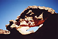
ALG-541, unnamed arch 127, Tin Kani Area. 2 meter height (estimated). From ALG-539 (Inner
Pillar Arch), hike back to the donkey trail on the flat area. Proceed on the trail northeast for
10 minutes toward the official bivouak of Tin-Kani called Tisouar. Pay attention on the left
(north), and you can see ALG-201 (unnamed arch 38) 300 meters away. This very fragile arch is
located on the way to ALG-201 on the sandstone wall close and to the right of ALG-201. The flat
area visible through the opening in this photo is where you approach the arch. Photo taken close
to sunset.
|
|
|
ALG-542, unnamed arch 128, Tin Kani Area. 2 meter span (estimated). From ALG-201 (unnamed arch
38) walk north 300 meters and find this arch where the rock masses become lower and less
dense.
|
|
|
ALG-543, unnamed arch 129, Tin Kani Area. 3.1 meter height (measured). GPS 32R 571233 2720882.
This pillar arch (there are numerous
representatives of this type of arch in Tassili) is located 1 km north of ALG-542 (unnamed arch
128). As the arch is well-hidden on a flat bowl inside a massive area of rock masses, it
requires a lot of time to seach for it.
|
|
|
ALG-544, Enesmer Arch, Tin Kani Area. 10 meter height (estimated).
GPS 32R 571762 2721191. From the trail by the side of Trophy Arch (ALG-191), hike down the rock
north for 300 meters to the hidden site of this arch. "Enesmer" means "nail"
in Tamahaq dialect.
|
|
|
ALG-545, unnamed arch 130, Tin Kani Area. 4 meter height
(estimated). This arch is located close to ALG-544 (Enesmer Arch) on the right of the isolated
spire visible in the photo of Enesmer Arch.
|
|
|
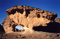
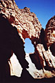
ALG-546, Prow Arch, Tin Kani Area. 2.5 meter height (estimated). This arch is located 2 km
north of ALG-544 (Enesmer Arch). As this arch is completly off trail and requires some ground
seach in a labyrinthine area, ask your guide to walk with you if you are interested to visit
this far away area. Of course, this recommendation is also valid for all isolated areas of
Tassili. Chief guide Mohamed Bilali poses below the arch for scale.
|
|
|
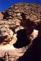
ALG-547, Concave Hole, Tin Kani Area. 1.5 meter height (estimated). This arch is located close
to ALG-546 (Prow Arch).
|
|
|
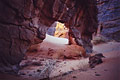
ALG-548, Little Surprise Arch, Tin Kani Area. 1.7 meter height by 1.2 meter span (both
measured). This small arch is located below ALG-194 (Surprise Arch). Note that Surprise Arch
sits above in the photo.
|
|
|
ALG-549, unnamed arch 131, Tin Kani Area. 2 meter height (estimated). From the view of ALG-201
(unnamed arch 38), rather than proceeding on the trail toward Tissouar campsite, leave the trail
and walk east 400 meters along a string of rocks to a break delimited by a small sand dune. The
arch is located there.
|
|
|
ALG-550, unnamed arch 132, Tin Kani Area. 2 meter height (estimated). From unnamed arch 131
(ALG-549), walk along the same line of rocks east for 300 meters to the arch on the side of the
rock.
|
|
|
ALG-551, unnamed arch 133, Tin Kani Area. 4.6 meter height (measured). GPS 32R 572602 2719970.
From ALG-550 (unnamed arch 132), walk along the same line of rock for another 300 meters to a
significant sand dune with an acacia tree hidden behind. Walk inside a corridor of rock located
behind these landmarks southeast for 200 meters to this arch, located near interconnecting
corridors. The author and crew bivouacked a night on the sand dune mentioned above. We had a
nocturnal visit by a poisonous viper, revealed by the glimmer of the campfire. We felt compelled
to track down the viper, with a headlamp, before we felt safe to sleep. It's very tricky to
track a viper at night because it moves fast. You can only see it with the pencil-like rays from
the headlamp and sometimes you lose sight of it. Never forget you are in desert surroundings in
a wilderness area. No rescue by helicopter is available here...so be careful, always.
|
|
|
ALG-552, Basement Arch, Tin Kani Area. 2.1 meter span (measured). From ALG-549 (unnamed arch
131), walk northeast on the sandy talus slope for 150 meters to the top of the hill. From there,
turn right and walk down into an obvious large sandy corridor. Walk 150 meters to this arch,
located on the right in the base of a little tower.
|
|
|
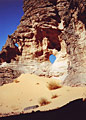
ALG-553, Arch of Silence, Tin Kani Area. 4.1 meter height
(measured). GPS 32R 572523 2720575. From the hill top described for ALG-552 (Basement Arch),
walk 500 meters north across a platform empty of rock outcrops to this arch. Photo taken close
to sunset. More photos of this nice arch can be found
here. 200 meters north
of this arch, you can find a
mushroom rock at a
higher elevation. This is the most elevated area of Tin-Kani site. From here you have a
spectacular view around the area, specially of the Tissouar bowl. The mushroom rock is also the
key to finding ALG-194 (Surprise Arch) nearby. This is the easiest way to find the well-hidden
Surprise Arch.
|
|
|
ALG-554, Big Foot Arch, Tin Kani Area. 4.4 meter height
(measured). GPS 32R 572990 2720125. From ALG-553 (Arch of Silence), walk 500 meters accross the
platform to the eastern corner of rock masses. The arch is located in these rocks. Photo taken
close to sunset.
|
|
|
ALG-555, unnamed arch 134, Tin Kani Area. 1.5 meter span (estimated). This small arch is
located 500 meters southeast of ALG-553 (Arch of Silence). Photo taken at sunset. The rocks seen
in the left background on the photo shelters ALG-554 (Big Foot Arch).
|
|
|
ALG-556, unnamed arch 135, Tin Kani Area. 1.5 meter span (estimated). This small arch is
located 200 meters east of ALG-555 (unnamed arch 134) on a drainage sloping down from the
platform to a sandy corridor. Photo taken at sunset.
|
|
|
ALG-557, Cyclop Rock, Tin Kani Area. 4 meter height (estimated).
From ALG-556 (unnamed arch 135), walk down the drainage to the corridor bottom. Walk this
corridor northeast 500 meters and you should be able to find this arch in some adjacent
corridors on the left. This is a labyrinthine area with a complex array of interconnecting
corridors but the opening is still easy to find.
|
|
|
ALG-558, Spiny Tailed Lizard Arch, Tin Kani Area. 8.1 meter span
(measured). GPS 32R 573326 2719998. This arch is located 300 meters northwest of ALG-557 (Cyclop
Rock). The name of the arch comes from the spiny tailed lizard (Uromastyx acanthinurus)
common to the Tassili region. The angle of the photo considerably decreases the apparent span of
the opening but shows the "lizard tail" as much as possible.
|
|
|
ALG-559, Upper Parallel Arch, Tin Kani Area. 8.8 meter span (main
opening, measured). GPS 32R 574049 2719941. This double arch is located 400 meters east of
ALG-557 (Cyclop Rock) up on the rocks. As the arch is not visible from the corridor floor, some
exploring and climbing on slick rock (not exposed) is required before seing the arch in its
higher position. You can spend hours hiking in the area and still miss what is here.
|
|
|
ALG-560, Lower Parallel Arch, Tin Kani Area. 4.9 meter height
(measured). This arch is located on the lower level of ALG-559 (Upper Parallel Arch). For scale,
guide Mohamed Bilali stands in the lower opening in the shadow and the author stands on the top
of the upper opening. This terrific shot is possible only around 4pm.
|
|
|
ALG-561, Symbol Arch, Tin Kani Area. 4.0 meter span (measured).
This arch is located 150 meters southwest of ALG-559 (Upper Parallel Arch). Ascend a slick rock
ramp (easy) to reach the arch on the left.
|
|
|
ALG-562, Sandy Corridor Arch, Tin Kani Area. 4.5 meter span
(estimated). This arch is located 100 meters west of ALG-560 (Lower Parallel Arch) at the bottom
of a deep sandy corridor.
|
|
|
ALG-563, Climber Arch, Tin Kani Area. 4 meter span (estimated).
This arch is located 150 meters north of ALG-560 (Lower Parallel Arch). The arch can be glimpsed
from a small patch devoid of rock beside ALG-560. Access to the arch requires some moderate free
climbing with some exposure. If you attempt this climb, please be careful. This shot was taken
with the help of Daniel Putelat, who climbed on an adjoining rock mass to obtain the best
picture possible. More views of this arch can be found
here.
|
|
|
ALG-564, Overlooked Arch, Tin Kani Area. 7.2 meter span
(measured). This arch is located 150 meters east of ALG-560 (Lower Parallel Arch) on a top of a
rock mass. Once again, this arch is unseen from the floor, and hence the name. You can walk very
close to it and never see the arch. The best way to find the arch is to explore systematically
each rock mass located close to the location given. Photo taken at sunset.
|
|
|
ALG-565, Oyster Shell Arch 1, Tin Kani Area. 2.5 meter span (estimated). Behind the rock mass
containing ALG-564 (Overlooked Arch), look for a narrow passage. Once in this passage, turn left
(northeast) into a little straight corridor. The arch is located inside the corridor on the
right.
|
|
|
ALG-566, Oyster Shell Arch 2, Tin Kani Area. 2 meter span (estimated). This arch is located in
the same straight corridor as ALG-565 (Oyster Shell Arch 1), further ahead and also on the
right.
|
|
|
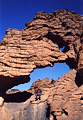
ALG-567, Chameleon Arch, Tin Kani Area. Main opening has a 6.4
meter span, medium opening has a 4.9 meter span, and small opening has a 1.5 meter span (all
measured). GPS 32R 574270 2720217. From ALG-566 (Oyster Shell Arch 2), descend east through a
chamber in a low wall of sandstone for 80 meters to this very attractive arch. The triple arch
has a striking ressemblance to a chameleon, hence the name. Note the specific posture of the
saurian, the two forelegs, and the protuberant eye. A beautiful photo can be obtained near 4 pm.
Guide Mohamed Bilali poses proudly under the main opening.
|
|
|
ALG-568, Angled Arch, Tin Kani Area. 4 meter height (estimated).
This arch is located 300 meters northeast of ALG-559 (Upper Parallel Arch).
|
|
|
ALG-569, unnamed arch 136, Tin Kani Area. 4 meter span (estimated). This arch is located near
ALG-568 (Angled Arch).
|
|
|
|
|
|
Index Page
|
|
Next Arch ALG-202
|
|