|
|

|
Natural Arches of Tassili National Park |
Index Page 17 - South Idou Area: The Needles - Map 8 & Map 9 |
|
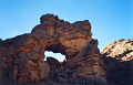
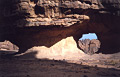
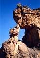
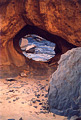
ALG-202, Little Pass Arch, Salihohen Pass Area. 7 meter span (estimated). From Djanet and
In-Abarba follow the 4WD tracks northeast into a large oued (wash). Then drive Oued Telegui to
the start of the trip in Oued Djewat, located 17 km from Djanet. Consult a guide to know how to
get here. From the end of the tracks hike upstream approximately 2 hours through hills of stone.
Then leave the Oued Djewat and climb a little gully (left) for about 15 minutes to the top of
the hill with numerous granite boulders. Climb down the hill into a drainage until another major
oued is reached. Follow this oued northeast for 1 hour or more to a junction with a wash coming
east. Climb up this wash to the east. There are several dry falls formed by granite boulders to
negotiate (sometimes difficult for a donkey). Continue on the trail eastward and ascend a ravine
to a little pass, approximately 1.5 hours from the junction (see photo on
Map 8 ). The arch is located on the side of the trail to
the left (the trail is visible in the background of the photo). Total hiking is about 6 to 6.5
hours, depending on the progress of the donkeys on the harder parts of the trail.
|
|
|
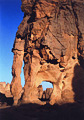
ALG-203, Salihohen Arch, Salihohen Pass Area. 12 meter span
(estimated). GPS 32R 553570 2736087. From ALG-202 (Little Pass Arch), proceed up on the trail
for 15 minutes to a large flat bowl. This area is usually used as a campsite for the night. The
arch is located on the west side of the bowl. Cross the flat 200 meters west to the arch up on
the slope. A very nice double guelta called "Le Frigo" (The Fridge) is located about a
15-minute hike to the east (check with your guide).
|
|
|
ALG-204A, unnamed arch 42. Three meter span (estimated). From ALG-203, cross the bowl to the
east and climb up the zig-zag trail into a second ravine to the top of a pass. Once on the
plateau top, climb down the trail to a little hollow (wash) and continue on the trail for about
40 minutes to where the arch is visible to the east some distance away at the beginning of the
rock maze area.
|
|
|
ALG-204B, Landmark Arch. 3 meters height (estimated). From ALG-204A, proceed on the trail for
30 minutes to a major junction. The trail goes southeast on the flat between the rock maze on
the left and a plateau ledge some distance on the right. This junction is located about 4 hours
hiking from ALG-203. The south trail goes to Tin-Aboteka and Tamrit Area. The left fork goes to
the Idou site via the Tin-Tekelt site. Take the left fork and walk approximately 3.5 hours and
pass the arch on the right side of the trail. The trail is nearly impossible to describe because
you walk continuously through a maze of rock. If you come in late November or early December you
will almost certainly need to camp for the night before reaching the arch (due to a 5:45 pm
sunset).
|
|
|
ALG-204C, Faraway Arch, Tin Tekelt Area. 4 meter span (estimated). From ALG-204B (Landmark
Arch), continue on the trail northeast and then north for 3 hours across a maze of roks to pass
this arch on the side of the trail. Only three arches (ALG-204A, B, and C) mark the way to the
Idou site. They are three good landmarks for this long journey.
|
|
|
ALG-207, Base Camp Arch, Idou Area. 1.5 meter height (estimated). GPS 32R 553092 2744952. From
ALG 204C (Faraway Arch, continue north on the trail about 2 hours and definitely leave the giant
maze area. Climb up to the desolate flat of the plateau. From there the trail connects with the
old half-track road of the Henri Lhote expedition (large cairn). Follow the old road north about
2 hours (not too exciting) before arriving in sight of the thousand needles of the goal - the
Idou site. Climb down the plateau by a side canyon and cross some outcropping rock to this arch
and the campsite. This is probably an unofficial camp. This is a long way from the start of the
trip (about 21 hours of hiking). However, the author was never bored by the great scenery of the
landscape along the trail. The Idou needles can be reached via Assakao pass with a total hike of
10 hours, less than half the time via Salihohen pass). The campsite is located on the east side
of the needles. Photo taken at sunrise.
|
|
|
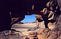
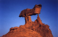
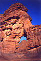
ALG-208, Caprock Arch, Idou Area. 1.5 meter span (estimated). From ALG-207 (Base Camp Arch),
walk cross country 300 meters south along the side rock to the arch. This arch is located close
to a "Mexican Hat" rock. Caprock Arch is an example of a
caprock natural arch. Photo taken at sunset.
|
|
|
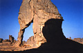
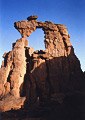
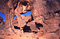
ALG-212, Raven's Perch Arch, Idou Area. 3.5 meter height
(estimated). GPS 32R 552587 2744747. From the "Mexican Hat" rock close to ALG-208
(Caprock Arch), walk northwest inside rock masses and cross an open area of slickrock. Walk 250
meters always northwest until reaching a sandy wash and a guelta (water hole). The guelta is
located at the end of a joint crack. Find this arch some distance beyond the guelta (northwest).
Photo taken at sunset.
|
|
|
ALG-211, Secret Guelta Arch, Idou Area. 2 meter height (estimated). From ALG-212 (Raven's Perch
Arch), walk 80 meters southeast and climb slickrock (easy) to a view into the joint crack canyon
and the second guelta located inside. The arch is located up on the rock above the guelta. The
"secret" guelta of clear water is accessible down the slickrock. The guelta can be dry
after a long dry period.
|
|
|
ALG-209, Fin Gate Arch, Idou Area. 3.5 meter height (estimated). GPS 32R 552519 2745590. From
ALG-212 (Raven's Perch Arch), walk south through ordered fins for 250 meters to this arch.
|
|
|
ALG-210, Canvas Arch, Idou Area. Triple opening, largest has a 2 meter span (estimated). This
unusual arch is located very close to ALG-209 (Fin Gate Arch) on an isolated rock.
|
|
|
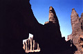
ALG-205, Idou Arch, Idou Area. 13.3 meter span (measured). GPS 32R
552356 2745783. From ALG-207 (Base Camp Arch), cross low rock masses northwest for 300 meters to
the huge chain of needles. This is an impressive area of innumerable high towers. You have to
hunt a bit to find the main passage inside this deep area. Once found, cross "The
Avenue" (cairned) to the other side of the chain of needles. You are no on the flat terrace
overlooking the desolate plain. On the terrace, look on the left for a side corridor. Walk south
into this corridor for about 100 meters to the arch hidden inside.
|
|
|
ALG-206, Idou Arch, second opening, Idou Area. 2.7 meter span (measured). Adjacent to ALG-205
(Idou Arch).
|
|
|
|
|
|
Index Page
|
|
Next Arch ALG-223
|
|