|
|

|
Natural Arches of Tassili National Park |
Index Page 18 - Tissoukai Area Islet 2 - Map 10 |
|
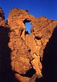
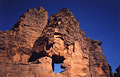
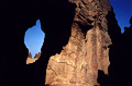
ALG-223, Amezzagh Arch, Tissoukai Area Islet Two. 5 meter height
(estimated). GPS 32R 551117 2755963. From ALG-207 (Base Camp Arch),
walk northeast some distance to reach the trail. Follow the trail along Oued Idou, which starts
in the needles of Idou. The trail goes northeast overhanging a big dryfall and follows the rim
of the following deep canyon. Then climb down the trail to reach the canyon exit and the oued in
the plain. Follow Idou wash and the trail downstream for 2.5 hours to the site of Tissoukai. The
trail sometimes goes along the bank and sometimes in the sandy wash, and crosses two major
hollows. At half way the trail passes close to the side of a maze on the left and some fin rocks
on the right. The camping spot and the arch are located at the GPS point given above. The camp
spot is 150 meters northwest off the wash and opposite a small islet of rock (islet 3 on
Map 10). The arch is up on the rock and inaccessible.
However, you can climb to a terrace above the camp spot via an easy chimney and get a close view
(as in photo, which was taken at sunset). Amezzagh means "camp" in the Tamahaq
dialect.
|
|
|
ALG-221, Fin Arch, Tissoukai Area Islet Two. 5.5 meter span
(measured). GPS 32R 550340 2755155. From ALG-223 (Amezzagh Arch), walk northwest inside the
islet for 150 meters to a large sand flat area. Cross the sand flat 450 meters in the same
direction to the large rock containing the arch. It is located close to a nice candle rock.
|
|
|
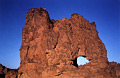
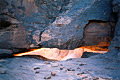
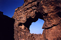
ALG-222, Cliff Wall Arch, Tissoukai Area Islet Two. 6 meter span
(estimated). From ALG-221 (Fin Arch), walk 150 meters north to the side rock. The arch is
located up on the rock. It is accessible by a detour. The arch is visible from a long distance
away. Photo taken at sunrise.
|
|
|
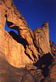
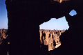
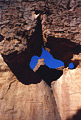
ALG-219, Scorpion Arch, Tissoukai Area Islet Two. 16.0 meter span
(measured). GPS 32R 549971 2755052. From ALG-221 (Fin Arch), walk west 350 meters to reach an
obvious side corridor. Walk inside the large corridor and find a chimney on the right. Climb up
the chimney (easy) to a terrace where the arch is located. Photo taken at sunset. Notice the
author on the top for scale.
|
|
|
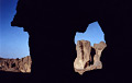
ALG-218, Chimney Arch, Tissoukai Area Islet Two. 2 meter span (estimated). This arch is located
above the chimney you climb to get to ALG-219 (Scorpion Arch), on the same terrace.
|
|
|
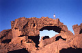
ALG-220, Skylight Arch (East), Tissoukai Area Islet Two. 3 meter span (estimated). From ALG-219
(Scorpion Arch), walk southwest 30 meters on the terrace to this arch. Another opening, Skylight
Arch (West) is located 80 meters to the right on the same terrace. It is the larger of the two
openings. The two arches can be visited from below by a detour route.
|
|
|
ALG-213, Exposure Arch, Tissoukai Area Islet Two. 3 meter height (estimated). From ALG-221 (Fin
Arch), walk south 300 meters to a sloped sand dune against the rock. The arch is located on the
rock above the sand dune.
|
|
|
ALG-214, Deadend Arch, Tissoukai Area Islet Two. 3 meter height (estimated). This arch and the
next two are located beyond ALG-213 (Exposure Arch) in the last string of rocks of the Islet 2
before the flat separating Islet 2 and Islet 1. Explore the area to find these arches.
|
|
|
ALG-215, unnamed arch 43, Tissoukai Area Islet Two. 2 meter height (estimated). This arch is
located close to ALG-214 (Deadend Arch).
|
|
|
ALG-216, unnamed arch 44, Tissoukai Area Islet Two. 2 meter height (estimated). This arch is
located close to ALG-214 (Deadend Arch).
|
|
|
ALG-217, unnamed arch 45, Tissoukai Area Islet Two. 3 meter span (estimated). Explore the area
around ALG-214, 215, and 216 to find this arch.
|
|
|
|
|
|
Index Page
|
|
Next Arch ALG-224
|
|