|
|

|
Natural Arches of Tassili National Park |
Index Page 23 - Tikoubaouine Area |
|
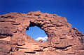
ALG-2, Touia Arch, Tikoubaouine Area. 11 meter span by 9 meter
height (estimated). GPS 32R 508681 2749422. From the "T" road junction at the gas
station in Djanet, drive north on the scenic road between Erg Admer (left) and Tassili Spur
(right) for 64.5 kilometers, or 58.5 kilometers from ALG-66 (Road Side
Arch). Leave the paved road northeast and drive off road (some tracks) through the little valley
for 9.5 kilometers to the arch. The arch is located up on the rock 500 meters before the trail
which goes to the Touia Guelta.
|
|
|
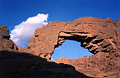
ALG-3, Agelman Arch, Tikoubaouine Area. 9 meter span (estimated).
GPS 32R 509191 2749568. This arch is located 500 meters east of ALG-2 (Touia Arch), where the
trail starts to Touia Guelta at the bottom of the little valley. Touia Guelta is located 10
minutes hiking up canyon from there. Agelman means "water hole" in the Tamahaq
dialect. "Guelta" has the same meaning in Arabic.
|
|
|
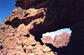
ALG-4, Teletmelt Oued Arch, Tikoubaouine Area. 4 meter span (estimated). GPS 32R 509889
2748646. From the bottom of the valley (see ALG-3), walk east for 2 minutes to reach Oued
Teletmelt. Walk downstream (south) for 800 meters to the arch, visible up on the rock, on the
right. Proceed down canyon in the wash for 200 meters and climb up as soon as possible on the
rock up to the opening (10 minutes). Nice view from the arch.
|
|
|
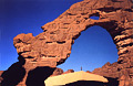
ALG-5, Tikoubaouine Arch, Tikoubaouine Area. 14.3 meter span
(measured), 20 meter height (estimated). GPS 32R 508260 2673794. This arch is located
approximately 3 kilometers southwest of ALG-2 (Touia Arch). It takes only five minutes to reach
the arch by jeep from Touia Arch. Tikoubaouine means "saber" in the Tamahaq dialect.
This is a magnificent double opening and this is the only officially named arch in this catalog.
|
|
|
|
|
|
Index Page
|
|
Next Arch ALG - 270
|
|