|
|

|
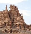
Natural Arches of Tassili National Park |
Index Page 24 - Tadrart AreaSee Tadrart Panoramic Photo by Tom Budlong |
|
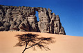
The Tadrart region, also called "Meridional Tadrart," is a part of the huge Tassili National
Park located in the southeastern Algerian Sahara desert. This vast region of mountains, canyons
and sand dune fields near the Libyan border is accessible only by jeep (approximately 170km from
Djanet or 6 hours driving). A guide is required by park rules. Take plenty of water with you,
since this area is known for extreme dryness, although there are gueltas in some of the shadowed
slots. You can come here with your own vehicle, or contact the Zeriba Agency to organize a
Tadrart tour. One week is recommended. The time passes quickly when you are having fun! A
Tadrart trip is more expensive that a Tassili donkey trip. You need a jeep (in good condition),
a driver, a guide, and a cook if you don't have your own food. Besides the incredible natural
arches, the region provides the visitor with other scenic natural wonders - among the best of
the immense Sahara desert. Also, Tadrart has magnificient rock art found all over the place.
|
|
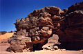
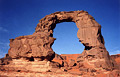
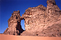
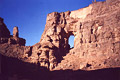
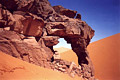
ALG-270, unnamed arch 67, undefined area. 8 meter span (estimated). The classic one week tour of Tadrart Region from Djanet passes by this arch on a 4WD road. Check with your guide. |
|
|
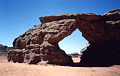
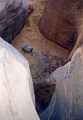
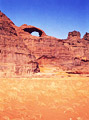
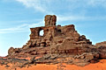
ALG-271, Mano Dayak Arch, undefined area. 20 meter height
(estimated). GPS 32Q 695207 2652670. The classic one week tour of Tadrart Region passes not so
far from this arch. The span can be viewed from several spots along the tracks. However, very
few persons take the time to visit it and still fewer climb up to it. The arch is located near
the head of a side pocket of ridge rock. The author bivouaced at the bottom of the arch and
climbed carefully to the opening via the south side. Mano Dayak (1950-1995), a Tuareg leader
from Niger, was an eager supporter of the Tuareg (Targuia) culture.
|
|
|
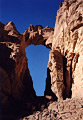
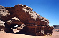
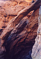
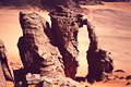
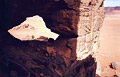
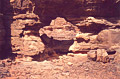
ALG-272, unnamed arch 68, undefined area. 5 meter span (estimated). This arch is located 600 meters before the left turn which leads you to the pocket that contains ALG-271 (Mano Dayak Arch). The arch is on the top of the rock beside a little pass of sandy tracks you used to get here. |
|
|
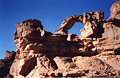
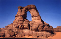
ALG-273, Lozenge Arch, Moul n'Aga Area. 7 meter span (estimated). GPS 32Q 697218 2654310. This arch can be seen in the distance from the 4WD tracks of the classic one week tour of the Tadrart region. The arch is surrounded by magnificient large sand dunes. |
|
|
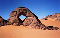
ALG-274, In-Tehaq Arch, In-Tehaq Area. 11.6 meter span (measured), 15 meter height (estimated). GPS 32R 693419 2672588. The one week tour of the Tadrart region passes by this arch. Check with your guide. Another magical free-standing (abandoned) natural arch of the Tassili. |
|
|
ALG-275, unnamed arch 70, undefined area. 9.7 meter span (measured), 15 meter height (estimated). GPS 32R 690684 2673794. The one week tour of the Tadrart region passes by this arch. Check with your guide. |
|
|
ALG-276, unnamed arch 71, undefined area. 4.8 meter span, 2.8 meters height (measured), 8 meters deep (estimated). This natural tunnel is located just behind ALG-275. In the photo, the two arches are shown together. ALG-276 is in the background, and ALG-275 is in the foreground. |
|
|
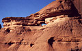
ALG-277, Tamezguina Arch 1, In-Djerane Canyon area. 30 meter height (estimated). GPS 32R 693232 2658259. The one week tour of the Tadrart region from Djanet passes by this arch. This magnificient arch is located at the crossroads of several tracks on the upper entrance of In-Djerane Canyon. Probably the most photogenic and best known arch of this part of the Park. The arch can be photographed together with ALG-278 from the northeast side. |
|
|
ALG-278, Tamezguina Arch 2, In-Djerane Canyon area. 45 meter height (measured with laser by Gunter Welz). This arch is located only 100 meters from ALG-277 (Tamezguina Arch 1). The span is best photographed in the afternoon from the south side with a large sand dune against the rock and ALG-279 (Tamezguina Arch 3) in the background. |
|
|
ALG-279, Tamezguina Arch 3, In-Djerane Canyon area. 15 meter height (estimated). This arch is located only 100 meters distant from ALG-278. These spans are a trio of unforgettable natural arches! |
|
|
ALG-280, Tin-Tararit Bridge, In-Djerane Canyon area. 1.5 meter height (estimated). From the trio of arches of Tamezguina, drive down stream in In-Djerane Canyon about one hour or so to a north side tributary which leads you to the guelta of Tin-Tararit. Check with your guide. The little bridge is located at the end of a slot canyon not far from the guelta. |
|
|
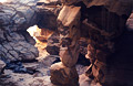
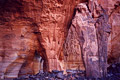
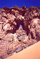
ALG-281, Dryfall Bridge of Tiseteka, In-Djerane Canyon area. 35 meter height (estimated). GPS 32R 683393 2663898. From the trio of arches of Tamezguina drive down stream in In-Djerane Canyon about 90 minutes or so to a north side tributary which leads you to the guelta of Tiseteka. Check with your guide. From the guelta climb the canyon upstream for 20 minutes to a pair of exciting and rare bridges. A little challenge awaits you to access these rewarding bridges. You have to bypass a very impressive huge, deep pothole (which is a bit scary for some people) before arriving in a cathedral of rock where these bridges sit. The main bridge has a vertical opening shown in this photo, with two supporting pillars forming a second opening (shown in foreground of photo for ALG-282). This incredible bridge has probably been seen by few people in this secret place. |
|
|
ALG-282, Dryfall Bridge of Tiseteka 2, In-Djerane Canyon area. 9 meter height (estimated). This bridge is located just 50 meters downstream from Bridge One. You cross it before you enter the secret chamber containing ALG-281. In the photo this bridge is in the background. You can see the two pillars forming the base of Bridge One in the foreground. |
|
|
ALG-415, Tiseteka Canyon Arch, In-Djerane Canyon area. 4 meter span (estimated). From In-Djerane Canyon, turn northeast into the side canyon of Tiseteka. Drive the canyon 400 meters to the arch located up on the rock to the left just past an amphiteater of rock. |
|
|
ALG-416, Dryfall Arches of Tiseteka, In-Djerane Canyon area. 3 meter height (larger opening, estimated). This double arch is located in the alcove above the bipod legs of Dryfall Bridge of Tiseteka (ALG-281). From the big dry pool, climp up the talus slope (easy) to the bench where this double arch is located. Note the nicely colored rock behind them. |
|
|
ALG-417, Four Giraffes Arch, In-Djerane Canyon area. 7 meter height (estimated). GPS 32R 685240 2663632. From the confluence of Tiseteka and In-Djerane Canyons, drive In-Djerane Canyon upstream approximately 2km to the arch, located on the left and visible from the tracks. The arch is located opposite to a fine panel of four engraved giraffes on the wall of the other side of the canyon. |
|
|
ALG-418, Tamezguina Arch 4, In-Djerane Canyon area. 20 meter height (estimated). GPS 32R 693522 2660182. This beautiful arch is located 1500 meters north of Tamezguina Arch 2 (ALG-278). From Tamezguina Arch 2, hike or jeep the flat to the arch visible in the distance. |
|
|
ALG-419, On the Top Arch, In-Djerane Canyon area. 2.5 meter span (estimated). This arch is located 1.5 km southwest of ALG-278 (Tamezguina Arch 2) on the top of a huge isolated rock mass. The rock mass contains a big crack with nicely sculpted rock in the entrance. Accessing the arch would require climbing aids. |
|
|
ALG-420, Superpillar Arch. 14 meter height (measured with laser by Gunter Welz). This buttress natural arch is located on the left side of the main Tadrart tour tracks approximately 4 km northeast (15 minutes drive) from the Arches of Tamezguina (ALG-278). |
|
|
ALG-421, unnamed arch 69. 2 meter span (estimated). From ALG-420 (Superpillar Arch) drive 1 km north of the main Tadrart Tour tracks to the middle sand hill. The arch is easily visible on the right. |
|
|
ALG-422, Orange Dunes Arch, Tin-Merzouga area. 4 meter span (estimated). This arch is well-hidden behind some orange dunes on the north of a noticable rounded silo-shaped rock. The wonderful setting of the arch makes a very nice picture. |
|
|
ALG-423, World Cup Arch 1. 12 meter span (estimated). This arch is located 500 meters west from the well known monolith attraction called "La Coupe du Monde" (World Cup). Note the person inside the span for scale. Photo by Gunter Welz. |
|
|
ALG-424, World Cup Arch 2. 7 meter span (estimated). This arch is located just behind ALG-423 (World Cup Arch 1) and visible in the picture of ALG-423 (dark hole). |
|
|
ALG-425, Tilafazo Arch, Tilafazo Area. 8 meter span (estimated), 7.5 meter height (measured with laser by Gunter Welz). |
|
|
ALG-441, Crag Arch, Tilafazo Area. 5 meter span, 5 meter height (larger opening, estimated). This double arch is located 500 meters north of Tilafazo Arch (ALG-425). Guilain Debossens is standing inside the opening. The climb to the arch has some exposed sections. Photo by Alene Watson. |
|
|
|
|
|
Index Page
|
|
ALG 265
|
|