|
|

|
Natural Arches of Tassili National Park |
Index Page 27 - Menkhor Area |
|
The Menkhor area is located about 25 kilometers to the southeast of the Alidemma area (about 40 minutes by four-wheel drive). Check with your guide. To get there, drive along the rock masses of the very end part of the Tassili-n-Ajjer plateau situated on the left and the huge black gravel talus on the right (the result of collapsed spires). |
|
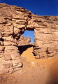
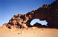
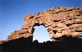
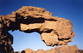
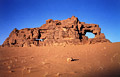
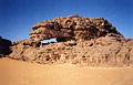
ALG-308, Menkhor Arch, Menkhor Area. 25 meters high (estimated). GPS 32Q 669848 2601287. Once you arrive in the Menkhor Area (from the Alidemma area) along Oued Menkhor, you can seen on the left a large open pit field lined with stones. Proceed straight ahead on the tracks toward the big massif visible in the distance. Five minutes later, look on the left into a large bowl. The arch sits gracefully at the bottom of the bowl encircled by big colorful sand dunes. The relationship of the magnificient span and the great surrounding landscape around makes visiting this spot an unforgettable moment. You cannot miss the arch. Daniel Putelat standing on top of the arch in the photo provides scale. |
|
|
ALG-309, Pottery Arch, Menkhor Area. 15.7 meter span (measured). GPS 32Q 671027 2601915. From ALG-308 (Menkhor Arch) go back to the tracks near Oued Menkhor. Then between Menkhor Arch and the big massif, drive northeast up the sandy slope (the only option) to a upper flat area. Drive the flat 1 km or so to the bottom end and find this arch on the right (east) among the scattered rock masses. |
|
|
ALG-310, Hideaway Arch, Menkhor Area. 7.8 meters span (measured). GPS 32Q 670225 2602207. From ALG-309 (Pottery Arch) drive north and cross the flat to this arch. The arch is only about 700 meters from ALG-309 but it is well hidden behind rock masses despite its high position. |
|
|
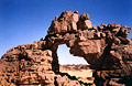
ALG-311, Marker Arch, Menkhor Area. 8.8 meters span (measured). GPS 32Q 668544 2601716. This arch is the first opening that can be seen up on the rock when arriving at the Menkhor site (3 minutes before a good look at Menkhor Arch). From Menkhor Arch go back toward the Oued and drive north to the bowl located behind the Menkhor Arch site. Then drive into the bowl to the bottom that is encircled by big sand dunes, staying on the left side of the rocks. Bypass the spires by driving the sandy tracks northwest into a hidden corridor (the only option) up to a field of sand dunes and rock masses. Now drive south 400 meters to the top edge of the cliff. Leave the jeep and find the arch on the top edge with less than 3 minutes hiking. |
|
|
ALG-312, Ephemeral Arch, Menkhor Area. 2 meter span (estimated). This arch is located just above ALG-311 (Marker Arch). The two arches can be photographed together in the morning. |
|
|
ALG-313, Rock Arch, Menkhor Area. Main opening has 5.2 meter span, 3.0 meter height (both measured). At the exit of the hidden corridor (on the tracks to ALG-311), once you are on the field of sand dunes and rock masses, find this arch to the north among isolated rocks. |
|
|
ALG-314, unnamed arch 74, Menkhor Area. 8.2 meter span, 5.5 meter height (both measured). GPS 32Q 668008 2602906. This arch is located 500 meters north of ALG-313 (Rock Arch) and it is accessible by jeep. Photo taken at sunset. |
|
|
ALG-315, unnamed arch 75, Menkhor Area. 5 meter span (estimated). This arch is located 200 meters north of ALG-314 (unnamed arch 74). Photo taken at sunset. |
|
|
ALG-316, unnamed arch 76, Menkhor Area. 7 meter span (estimated). This arch is located 100 meters to the south of ALG-314 (unnamed arch 74). |
|
|
ALG-317, Out of Joint Arch, Menkhor Area. 8.4 meter span, 6.0 meter height (both measured). GPS 32Q 667306 2603587. This arch is located 500 meters to the north of ALG-314 (unnamed arch 74). This is a true arch. The nickname comes from the fact that the upper part is out of joint (not the span). |
|
|
|
|
|
Index Page
|
|
ALG 341
|
|