|
|

|
Natural Arches of Tassili National Park |
Index Page 37 - In-Essou Area |
|
INTRODUCTION: The In-Essou main site is located two hours of hiking north from Ozaneare campsite, or one hour of hiking south from Tin-Kani site. A direct way coming from Jabbaren site takes three hours of hiking across the plateau on open land. The main site has few natural arches because the "Tamrit sandstone" formation occurs in this area which is less favourable to the development of rock openings. However, the central area of In-Essou displays many majestic rock spires and needles such as Square Tower and Candle Rock. Half way between Ozaneare and In-Essou localities, Ichoumar Arches (ALG-526 and ALG-527) form a nice landmark on the trail. The most impressive arch is El Mandar Arch (ALG-533) — a real gem — which is located in the vicinity of In-Essou and ranks among the best arches of the entire Plateau. |
|
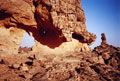
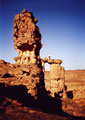
ALG-526, Ichoumar Arch I, In-Essou Area. 5 meter height (estimated). GPS 32N 575191 2716224. This nice arch is located half way between Ozaneare and In-Essou localities. It take 1 hour of hiking if you come from Ozaneare campsite before you pass beside the arch on the trail. If you comes from Rayeye site, 20 minutes are sufficient to get to the arch. The Tamahaq name "Ichoumar" is a contraction of the French name "chomeur" (unemployed person), which refers to the "clandestine people" who reach Libya in secret by crossing the plateau. The author was surprised to see here a long human caravan of about sixty "ichoumar" people coming from black Africa (usually Niger). It was a surrealist image after seeing nobody for days and days. Note the author up on the arch for scale. |
|
|
ALG-527, Ichoumar Arch II, In-Essou Area. 1.5 meter height (estimated). This small arch is located at the foot of ALG-526 (Ichoumar Arch I). |
|
|
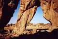
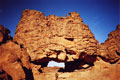
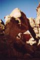
ALG-528, Double Gate Arch I, In-Essou Area. 3.9 meter height (measured). From Ichoumar Arches (ALG-526 and ALG-527), use Ichoumar trail to the east in the direction of the Libya border. Quickly after leaving the arches, the trail goes down a steep slope behind the arches to reach a canyon bottom. Once on the wash bottom, follow the canyon (east) to a short narrow passage. Cross the narrows and at the exit leave the wash and short-cut a large meander. Then walk on flat area of the trail toward a massive tower. Once close to the large tower, this double arch is located on the right. The massive tower is shown in the photo. It takes only 30 minutes to reach here from Ichoumar Arches. |
|
|
ALG-529, Double Gate Arch II, In-Essou Area. 2.2 meter span (measured). This arch is adjacent to ALG-528 (Double Gate Arch I). |
|
|
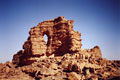
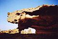
ALG-530, Caprock Tower I, In-Essou Area. 10.0 meter height (measured). GPS 32N 577128 2716575. This exceptional arch is located 300 meters east of ALG-528 and ALG-529 (Double Gate Arches) — after the large meander, re-cross the wash on the way to this arch. Note the author up on the arch for scale. Note that this is also a caprock type arch. |
|
|
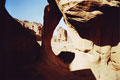
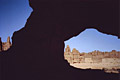
ALG-531, Caprock Tower II, In-Essou Area. 1.7 meter height (measured). This small pillar arch is located at the base of ALG-530 (Caprock Tower I). Note that the massive tower next to ALG-528 is visible through the opening in the background. |
|
|
ALG-532, Rock Mass Arch, In-Essou Area. 9.0 meter span (measured). From Caprock Tower (ALG-530), walk up steeply 200 meters eastward to this arch, located on the left. It is hard to get a good photo of this interesting arch due to the difficulty of getting enough depth of field to keep the foreground rocks in focus. |
|
|
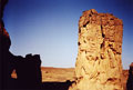
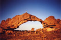
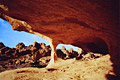
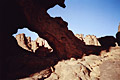
ALG-533, El Mandar Arch, In-Essou Area. 22.0 meter span by 7.2 meter height (both measured). GPS 32N 577624 2716710. Cross under ALG-532 (Rock Mass Arch) and walk east 400 meters to this splendid and fragile arch. You cannot help to notice this arch even if you have little interest in natural arches. It is a real gem. Note the author on the top for scale. "El Mandar" means "landscape" both in the Arabic language and in the Tamahaq dialect. Photo taken close to sunset. |
|
|
ALG-534, Niche Arch, In-Essou Area. 2.5 meter span (estimated). This small arch is located close to and west of ALG-533 (El Mandar Arch). |
|
|
ALG-535, unnamed arch 124, In-Essou Area. 3.7 meter span (measured). This arch is located close to and southwest of ALG-533 (El Mandar Arch). |
|
|
ALG-536, unnamed arch 125, In-Essou Area. 2.5 meter span (estimated). Between ALG-528 and 529 (Double Gates) and ALG-530 and 531 (Caprock Tower) there is a confluence of two washes. Walk the southeast wash (oued) for 400 meters and look for this arch up on the rocks to the right. |
|
|
ALG-537, In-Essou Arch, In-Essou Area. 4.9 meter span (measured). GPS 32N 572813 2718724. From ALG-526 and 527 (Ichoumar Arch) continue north on the trail to the main site of In-Essou for 40 minutes. The arch is located on the edge of the wonderful needles not far from Oued Timeseous. |
|
|
ALG-538, unnamed arch 126, In-Essou Area. 3 meter span (estimated). From ALG-537 (In-Essou Arch), there are two ways to reach the nearby site of Tin-Kani. Usually guided hikers take a short cut across an attractive landscape of rock towers and needles (with no arches) on mostly sandy terrain. The donkey pack and donkey driver take a bit longer route. Here is described the donkey trail which starts along the edge of the needles. Walk on the donkey trail north for 15 or 20 minutes and pay attention on the right. This arch is visible some distance away on the right through big towers. |
|
|
|
|
|
Index Page
|
Home
|
|