|
|

|
Natural Arches of Tassili National Park |
Index Page 1 - Djanet and Akba Tafilalet Areas - Map 1See Tafilalet Panoramic Photo by Tom Budlong |
|
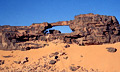
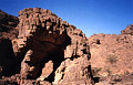
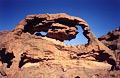
ALG-66, Roadside Arch, Djanet Area. 5.2 meter span (measured).
From the "T" road junction at the gas station in Djanet, Algeria, drive north 5 km in
the direction of Illizi to the top of the sand hill and the road sign "Borj-el-houes 120
km". Proceed 1 km past this sign and you can see the arch on the right side of the road.
|
|
|
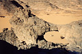
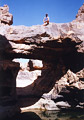
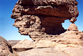
ALG-67, Dromedary Arch, Djanet Area. 8 meter span (measured). GPS
32R 543986 2709992. The arch is located in the butte behind ALG-66. You can climb on top of the
arch by ascending a side ravine. A dromedary seen through the opening fortuitiously posed for
this shot.
|
|
|
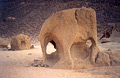
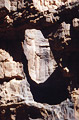
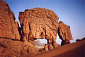
ALG-69, The Elephant, Djanet Area. This small arch eroded in a granite boulder is located
approximately 3 km south of the old French landing strip. Contact the Zeriba Agency to visit the
arch.
|
|
|
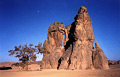
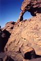
ALG-68, Crying Cow Arch, Djanet Area. From Djanet center drive road south toward Tiska-Djanet
Airdrome for 25.6 km and turn right. Drive the sandy tracks about 4 km to the famous engraving
site of Tagherghert/La Vache Qui Pleure (Crying Cow). The
arch is located behing the rock mass.
|
|
|
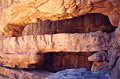
ALG-261, Ouafararen Oued Arch, Djanet Area. 15 meters deep
(natural tunnel), 8 meter height (estimated). GPS 32R 536810 2740395. From Djanet center
(bridge) drive paved road to In-Abarba and proceed on the 4WD road (north) until the end of the
suitable road for motor vehicles (20km from Djanet center). This road leads to Assakao pass and
the top of the Tassili. However the road is now impassable (numerous washouts). Walk the 4WD
road (north) two hours to the side of the Oued Ouafararen. The natural tunnel is located 100
meters off the road (west) at the canyon entrance.
|
|
|
ALG-326, Quadruple Arch, Djanet Area. 7.0 meter span (largest
opening), 5.0 meter span (second largest opening), both measured. From ALG-261 (Ouafararen Oued
Arch) walk Ouafararen Oued downstream into the canyon for 30 minutes to the quadruple arch on
the right. In the photo only the two lower openings (the largest two) are visible.
|
|
|
ALG-327, Beybey Guelta Arch, Djanet Area. 2 meter height (estimated). Arch is inaccessible. GPS
32R 535129 2739436. From ALG-326 (Quadruple Arch) walk Ouafararen Oued canyon downstream through
the short and very nice narrows for 30 minutes to the junction with Beybey Oued (large wash).
Turn right (north) and walk Beybey Oued upstream for 30 minutes to the Beybey Guelta (large
sandy pool). The arch is located 200 meters before the guelta, on the right.
|
|
|
ALG-328, Natural Bridge of Tassili, Djanet Area. 6 meter height
(estimated). GPS 32R 535913 2741344. From ALG-261 (Ouafararen Oued Arch) walk Ouafararen Oued
upstream 400 meters to a wash junction. Leave Ouafararen Oued and turn left (north) into the
wash. This is where the old 4WD road crosses the wash and continues north into this wash.
However, there is no trace of road in the wash. Upper Ouafararen Oued going east is usually used
to go back down from Assakao Pass via Guelta Semid when donkeys carry light packs after the
trip. 7 hours hiking is necessary to go back down to this point. Now, proceed into the
north wash 300 meters and climb up and down the old road on the left another 300 meters. Recross
the oued and climb up the old road 300 meters to the top of a small hill. As soon as the road
goes down look on the left (northwest) into the wash. The natural bridge can be seen near a
small dryfall. From there take the path 500 meters which takes less than 5 minutes to the guelta
and the bridge. An alternative route is to follow the wash directly from the junction to the
bridge. There is a permanent pool of water (big pothole) under the bridge and it is very
photogenic. If you proceed up the old road you can reach Assakao Pass from there in about 8
hours hiking, and can reach the Tissoukai-Idou sites in another 3 hours (see Index Pages 18 to
21).
|
|
|
ALG-510, Timbeur Vista Arch, Djanet Area. 2 meter span (estimated). From the white mosque of
the village of In-Abarbar (located 5 km north of Djanet center at the end of the paved road),
walk north 600 meters out of the village to a sand dune field and an interesting
balanced rock. The
arch is located 300 meters to the northeast of this balanced rock. The name of the arch comes
from the view through the opening of the famous Timbeur Peak which rises above the north end of
the oasis of Djanet.
|
|
|
ALG-6, Top Pass Arch, Akba Tafilalet Area. 2 meter span and 2 meter height (estimated). From
main street in Djanet, turn right on paved road just before the bridge and drive 400 meters to
the fire station. Take the 4WD road east and drive about 16 km to the turnaround (shelter) at
the bottom of the huge cliff of Tassili-n-Ajjer. From there climb up the ravine on the cairned
donkey trail to the flat bowl with some acacia trees (about 45 minutes). Cross the bowl straight
ahead 300 meters and turn right into the canyon. Walk 500 meters through the canyon and take the
ascending pass on the left to a pass. Then go down the trail to a rocky wash (oued) into the
upper Akba Tafilalet Canyon. Once on the canyon floor you can see a slot canyon on the right and
a high spire perched on the left. Proceed in the canyon upstream for approximately 2 km and turn
right at a cairn. Climb up the strenuous ravine (hard part of the trail) to the top of the pass
(there is a pour off on the right). Find this arch on the left of the pass on the rocks above
it. So far I have described the donkey trail, but several short cuts exist. All are shown on
Map 1. For example, at the cairn described above where you
turn right, an alternate route is to continue on the trail straight ahead and ascend a hard
chimney into a side canyon before arriving at the plateau top (for strong hikers only). This way
saves 30 minutes of hiking.
|
|
|
ALG-70, Nutcracker Arch, Akba Tafilalet Area. A triple arch. The main opening is 4.5 by 3.5
meters (estimated). GPS 32R 563723 2720434. From the top of the pass proceed on the burro trail
and negotiate a big "S" curve. Then the trail passes through a low corridor of rocks
and emerges after a small saddle on very flat desolate terrain, about 15 minutes from the top of
the pass. From the small saddle retrace your steps about 125 meters and find the triple arch on
the right near the canyon rim.
|
|
|
ALG-71, Nutcracker Arch Lower, Akba Tafilalet Area (see ALG-70).
|
|
|
|
|
Index Page
|
|
Next Arch ALG-72
|
|