|
|

|
Natural Arches of Tassili National Park |
Index Page 35 - Other Arches |
|
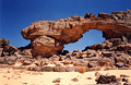
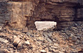
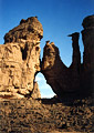
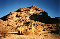
ALG-262, Timras Arch, Timras Area. 6.0 meter span, 2.0 meter height (measured). GPS 32R 532562
2717790. This arch is located in Timras area in the plain level of the Tassili Spur. The area of
Timras can be reached by driving numerous interwining sandy tracks starting near
ALG-66, or a longer route from the scenic paved road described with
ALG-2 . The arch is accessible by jeep. Consult a guide to know how to
get there, or track down the arch with the GPS coordinates provided. Timras means "tooth" in the
Tamahaq dialect. This area has natural splendor reminiscent of Monument Valley. Aerial and other
photos of the Timras area can be found
here.
|
|
|
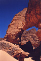
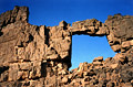
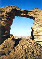
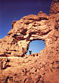
ALG-263, Jefamoud Arch, Jefamoud Area. 18 meter span (estimated).
GPS 32R 515466 2736119. This arch is located in the Jefamoud area in the level plain of Tassili
Spur. This area is located north of Timras area and south of Tikoubaoune area. The arch is
accessible by jeep. However, numerous interwining sandy tracks are confusing and prevent any
route description. Consult a guide to know how to get there and track down the arch with GPS
coordinates.
|
|
|
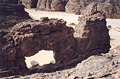
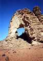
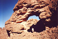
ALG-264, unnamed arch 62, north of Timras Area. 6.9 meter span, 6.3 meter height (measured).
GPS 32R 525879 2726688. This arch is located on the level plain of the Tassili Spur north of
Timras area. The arch is accessible by jeep via numerous intertwining and confusing sandy tracks
through labyrinthine rock masses.
|
|
|
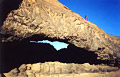
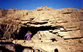
ALG-442, Tililine Arch, Tililine area. 4 meter span (estimated).
Tililine area is located just southeast of the Tikoubaouine area and it is accessible by jeep
via paved road from Djanet to Borj-El-Haous. Once in the area go to GPS point 32R 514686E
2741756N where an alcove type natural arch is located up on the rock. From there walk north 900
meters to Tililine Arch located up on the rock. The photo was taken from above to show the
landscape around the arch.
|
|
|
ALG-443, Debris Arch, Tililine area. 6.5 meter span (measured).
From ALG-442 (Tililine Arch), walk 400 meters north and look for the arch visible up on the rock
(east). Climbing to the arch is steep but not difficult. The arch is located close to the Oued
Emahrachali. Check with your guide.
|
|
|
ALG-444, Tamasak Arch, Tamasak area. Main opening 4.8 meter span,
3.5 meter height (both measured). GPS 32R 517749 2739169. Tamasak area is close to Tililine area
and it is accessible by jeep. Use GPS coordinate to locate this double arch. Tamasak area is the
starting point for dromedary trip across Tassili spur and back to Djanet. From this point, the
author took 6 hours of hiking to reach Itilaoulaoutine Area (ALG-446 and ALG-447).
|
|
|
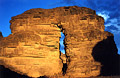
ALG-445, Arc de Triomphe, Tamasak area. 8 meter height
(estimated). This arch is located 100 meters to the east of Tamasak Arch (ALG-444). Photo taken
at sunset.
|
|
|
ALG-446, Itilaoulaoutine Arch, Itilaoulaoutine area. 9.8 meter
span, 7.2 meter height (both measured). GPS 32R 521120 2740954. This beautiful arch is located
in Itilaoulaoutine area on the side of the oued (wash) of the same name and close to a cave
containing some painting. This area can be reached from Tililine area via a six hour hike.
Tililine area is accessible by jeep and usually a dromedary caravan is used to come to
Itilaoulaoutine area. A guide is obligatory by park rules.
|
|
|
ALG-447, Ostrich Rock Arch, Itilaoulaoutine Area. 7.8 meters span
(measured). GPS 32R 520428 2741579. From Itilaoulaoutine Arch (ALG-446) walk north in Oued
Itilaoulaoutine for 800 meters and find this arch just above the wash in the rock masses. The
arch is located close to a small pillar arch up on the rock.
|
|
|
ALG-474, Erass Arch. 30.0 meter span (measured). GPS 32R 483786
2757217. On road N3 (between Djanet and Bordj-El-Haoues, 90km north of Djanet) or 10 km past the
famous Essendilene Oued (signed), leave the paved road at KM post 2020 and drive the desert
track toward an obvious valley northeast. Most of the tracks go along a faint oued. After
approximately 8 km drive up a sand slope and stop on the other side. There is a oued on the
right and huge fallen blocks from a tower on the left. Near the fallen blocks hike north to an
obvious little pass (3 minutes) to the view of the next valley. The magnificient arch is visible
from there to the north standing magically on the top of a small butte. Hike 15 minutes north to
the arch.
|
|
|
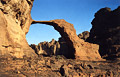
ALG-475, Circle Arch I. 30.0 meter span (measured). GPS 32R 489334
2757350. On road N3 89 km north of Djanet T-junction (see
road log), leave the paved road at KM post 2021 (signed
Oued Tananet) and drive tracks northeast along Oued Tananet for 20 minutes to 3
"Zeribas" (shepherd huts). From there, leave Oued Tananet and drive east 3 km on the
flat and park. Note that ALG-476 (Circle Arch II) is visible from the parking spot giving to you
a good idea where the arch is located. From a big Acacia tree, hike up a goat trail 20 minutes
to the arch. This is a monumental arch eroded in a colossal half-circle rock mass. Hence the
name. Each side of the main opening has another arch. The left side contains ALG-476 and the
right side contains a very nice natural tunnel making this place a great spot.
|
|
| ALG-476, Circle Arch II. 12.0 meter span (measured). This arch is located on the left side of ALG-475 (Circle Arch I) in the upper inner rock mass. Note that Oued Tananet is visible in the background through the opening. |

|
|
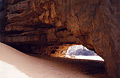
ALG-477, In-Abai Natural Bridge, Adrar Area. 38.0 meter span
(measured). GPS 29R 578767 2755819. This arch is located in the Adrar Mountains area of the huge
Tassili National Park (please do not confuse the name"Adrar" with "Tadrart"
which is located 300 km to the southeast). In Bordj-El-Haoues town (140 km north of Djanet
T-junction) stop at KM post 1974 an the obligatory police checkpoint. Then drive main street
(Road N3) north to KM post 1972 (2 km more). 200 meters before KM post 1971, turn left between
two houses, cross the Oued and drive the desert track on the flat for 50 minutes northwest
toward Adrar Mountains to the famous In-Thae Guelta (which means "black guelta" in the
Tamahaq dialect). In-Thae Guelta is a splendid pool of water with an abundance of reeds located
below a lava waterfall. This is also at the end of the rough 4WD tracks. From there, drive back
the way you came for 5 minutes (or 15 minute walk) along the lava canyon of the Oued Tabaket to
In-Abai ("the hole" in Tamahaq), a big lava natural bridge located on the side of Oued
Tabaket. Note the author's friend Mohamed Touggui on the top of the bridge for scale.
|
|
|
ALG-478, In-Amoureden Arch, In-Amoureden area. 8.0 meter span by
6.2 meter height (both measured). GPS 29R 474040 2726716. This arch is located up on the rock on
the side of the classic Timras-Tikoubaouine tracks, 600 meters before passing ALG-264 (unnamed
arch 62). For landmarks, the arch is located just opposite to a nice small balanced rock on the
side of the tracks. Note the author's friend Mohamed Touggui inside the span for scale.
|
|
|
ALG-479, Shepherd Hut Arch, Tilafazo area. Main opening 8.0 meter
span, second opening 3.0 meter span (both measured). This double arch is located in Tilafazo
area 15 minutes drive northeast of In-Amoureden Arch (ALG-478). Check with your guide and
driver. The arch is accessible by jeep. Note the shepherd hut on the foreground. Please do not
confuse Tilafaso Area in Tassili-n-Ajjer with Tilafazo Area in Tadrart area (same name but two
different geographic areas in the same National Park). The second opening is not visible in the
photo.
|
|
|
ALG-480, Side Tracks Arch, Tilafazo Area. 8.4 meter span (measured). GPS 29R 476981 2729749.
This arch is located 200 meters southwest of ALG-479 (Shepherd Hut Arch) next to the jeep
tracks. Mohamed Touggui from travel agency Djarat Tours poses beside the opening for scale.
|
|
|
ALG-481, Akzel Guelta Arch. 8.0 meter span (measured). GPS 29R
473247 2729578. This arch is located near Akzel Guelta (or Aguelman Akzel in Tamahaq dialect).
This big pool (pothole) is located 10 minutes drive from In-Amoureden Arch (ALG-478) or 10
minutes drive from Tilafazo area by jeep. However the guelta is not directly accessible by jeep.
Drive up Oued Tasoutrat as far as possible (it's a sand trap). Then walk Oued Tasoutrat
into the large canyon approximately 20 or 30 minutes (depending where your driver stops the
jeep) to the guelta. The guelta can be dry sometimes, as was the case when the author visited
this canyon. Bypass the big pothole via a ledge (easy) and continue up canyon 200 meters. The
arch is visible up on the rock on the right. To access the opening, climb up the ravine with
caution (many loose boulders) for 10 minutes. The climb is strenious but does not require
rope.The arch is worth the effort of the climb. There is an oustanding view of the area from the
bench above the arch. Note the author in the arch for scale.
|
|
|
|
|
|
Index Page
|
|
Next Arch ALG-514
|
|